Visit our other Wisconsin Historical Society websites!
 Filter: Categories of Wisconsin Historical Images
Filter: Subject of Bridges
Filter: Subject of human settlements
Filter: Subject of trees
Filter: Categories of Wisconsin Historical Images
Filter: Subject of Bridges
Filter: Subject of human settlements
Filter: Subject of trees

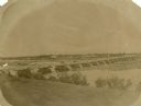
| Date: | 01 1934 |
|---|---|
| Description: | Aerial view of New Butler, in Waukesha County. |

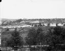
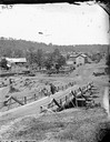
| Date: | 1905 |
|---|---|
| Description: | Elevated view of Soldiers' Grove with a bridge in the foreground. |
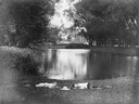
| Date: | 1870 |
|---|---|
| Description: | View from shoreline over river towards the town. |
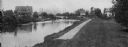
| Date: | 1908 |
|---|---|
| Description: | A view of the Yahara River below Williamson Street. |
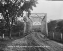
| Date: | |
|---|---|
| Description: | View down a metal bridge over the Kickapoo River showing a truck parked on the far side of the bridge. A man and a boy are standing at the rail of the brid... |
| Date: | |
|---|---|
| Description: | Elevated view from south side of the Chippewa River, with a bridge crossing it and buildings on both sides of the river. A bluff rises on the far side of t... |

| Date: | 1856 |
|---|---|
| Description: | View looking west from Lake Michigan with several steam ships and sailing vessels in harbor. There is a lighthouse to left of center, along shoreline. |
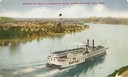
| Date: | 1909 |
|---|---|
| Description: | Elevated view of the sidewheel excursion, Saint Paul, on the Mississippi River taken in 1909. St. Paul, Minnesota is seen in the background. Later n... |
| Date: | |
|---|---|
| Description: | Two boys lying on the grass asleep in Tenney Park near the lagoon with a hat on the ground between them. The Sherman Avenue bridge and the Hausmann Brewery... |
| Date: | |
|---|---|
| Description: | View of Kilbourn, with Superior Street bridge in Happy Hollow. Two men are standing on a bridge. Buildings and stacked lumber are in the background. |

| Date: | 1867 |
|---|---|
| Description: | Birds-eye drawing of Appleton, Outagamie Co., depicting street names and street layout, houses, the Fox River, the court house, jail, school houses, Lawren... |
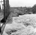
| Date: | 1916 |
|---|---|
| Description: | Water churns under a railroad bridge as the spring thaw swells the Wisconsin River. |

| Date: | 05 31 1965 |
|---|---|
| Description: | Elevated view of Evangelical United Brethren church in the vicinity of Highway T. |
| Date: | |
|---|---|
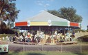
| Description: | Children riding the carousel (merry-go-round) at Henry Vilas Zoo (Vilas Park Zoo), donated by the citizens of the Madison area. A stone bridge is in the ba... |
| Date: | 1904 |
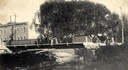
|---|---|
| Description: | View across Yahara River towards a group of people on the Sherman Avenue Bridge, with the old malt house in the background. |

| Date: | 1868 |
|---|---|
| Description: | This 1868 birds-eye view depicts the buildings, streets, railroad, vegetation and topography of Columbus, Wisconsin. The high school, cemetery, railroad de... |

| Date: | 1884 |
|---|---|
| Description: | Bird's-eye map of Delavan with inset of the State Institute for Deaf and Dumb. |

| Date: | 1867 |
|---|---|
| Description: | Bird's-eye map of Green Bay and Fort Howard, Brown Co., depicts street names and street layouts, houses, trees, and the East River. A reference key at the ... |

| Date: | 1867 |
|---|---|
| Description: | Bird's-eye map of La Crosse with nine insets of residences, schools, and the Court House and Jail. |
If you didn't find the material you searched for, our Library Reference Staff can help.
Call our reference desk at 608-264-6535 or email us at:
