 Filter: Categories of Wisconsin Historical Images
Filter: Subject of Bridges
Filter: Subject of human settlements
Filter: Subject of canals
Filter: Categories of Wisconsin Historical Images
Filter: Subject of Bridges
Filter: Subject of human settlements
Filter: Subject of canals

| Date: | 1872 |
|---|---|
| Description: | Birds-eye drawing of Eau Claire depicts street names and street locations, houses, trees, bridges, piers, canals, railroads, and the Chippewa and Eau Clair... |

| Date: | 1892 |
|---|---|
| Description: | Bird's-eye map of Princeton, with an inset of the Residence of F.T. Yahr. Fox River loops to left of center, with one bridge; thirty-six businesses, reside... |
| Date: | |
|---|---|
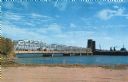
| Description: | View of the bridge spanning the Sturgeon Bay canal. |
| Date: | |
|---|---|
| Description: | View from the shoreline of a bridge spanning the Sturgeon Bay canal. |

| Date: | 1870 |
|---|---|
| Description: | The corner of unpaved Main Street and Tayco Street looking south towards Doty Island. The slanting timbers controlled the primitive draw bridge across the ... |

| Date: | |
|---|---|
| Description: | Plat map of the east central part of the city. |
| Date: | |
|---|---|
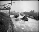
| Description: | Elevated view of tugboat pulling a steamer caked in ice in a canal. Steam is rising from the water and an open drawbridge can be seen in the background. On... |
| Date: | |
|---|---|
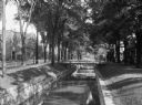
| Description: | View of a tree-lined waterway that runs through a residential area. The street and commercial buildings are on the left, and there are footbridges from the... |

| Date: | |
|---|---|
| Description: | Bird's-eye view of the north branch extension canal on the Susquehanna river, surrounded by smaller renderings of structures of interest around the town in... |

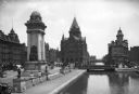
| Date: | 1893 |
|---|---|
| Description: | View of the canal area of the Columbian Exposition grounds looking north from near the front of the Machinery building (at left). The South canal is in the... |
| Date: | |
|---|---|
| Description: | View of Masonic Park featuring the Erie Canal and the Soldiers and Sailors Monument, dedicated in 1909. The Empire House can be seen at left, constructed i... |

| Date: | 1856 |
|---|---|
| Description: | ". . . The upper Grand Chute was the last of the 'improvements' paintings signed by Brookes and Stevenson. Yet there were two more vital links in the Fox R... |

| Date: | 1831 |
|---|---|
| Description: | Map of the city of Louisville, Kentucky on the Ohio River showing streets and numbered lots. The Ohio River, Corn Island, and the Louisville and Portland C... |

| Date: | 1874 |
|---|---|
| Description: | Bird's-eye view map of Appleton, Wisconsin. Map reads: "NOTE.-Since the above cut was engraved, the Fox River Pulp & Paper Co.'s Mammoth Mills have been er... |

| Date: | 1855 |
|---|---|
| Description: | This map shows landownership, lot and block numbers, streets, a canal, bridges, Fort Winnebago, the Wisconsin River, and the Fox River. Relief is shown by ... |

| Date: | 1907 |
|---|---|
| Description: | This map is a chart of Milwaukee Harbor that displays local streets, bridges, roads, railroads, public buildings, businesses, factories, dry docks, parks, ... |

| Date: | 1874 |
|---|---|
| Description: | Birds-eye view of Appleton Wisconsin. In the foreground are people fishing, strolling, and looking over the canal towards the Fox River. Streets and buildi... |

| Date: | 11 15 1918 |
|---|---|
| Description: | View towards three sets of railroad tracks, each branching off to the left and right between factory buildings. Railroad cars are on another set of tracks ... |

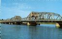
| Date: | 1935 |
|---|---|
| Description: | Text on front reads: "Bridge at Sturgeon Bay, Door County, Wisconsin." This bridge, also known as the Michigan Street Bridge, was built in 1929 and opened ... |
If you didn't find the material you searched for, our Library Reference Staff can help.
Call our reference desk at 608-264-6535 or email us at:
