 Filter: Categories of Wisconsin Historical Images
Filter: Subject of Bridges
Filter: Subject of human settlements
Filter: Community of La Crosse
Filter: Categories of Wisconsin Historical Images
Filter: Subject of Bridges
Filter: Subject of human settlements
Filter: Community of La Crosse
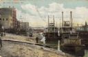
| Date: | 1900 |
|---|---|
| Description: | Riverboats tied at the levee in La Crosse with the Gypsy in the foreground. Caption reads: "The Levee, La Crosse, Wis." |

| Date: | 1867 |
|---|---|
| Description: | Bird's-eye map of La Crosse with nine insets of residences, schools, and the Court House and Jail. |

| Date: | 1873 |
|---|---|
| Description: | Bird's-eye map of La Crosse from the Mississippi River. |

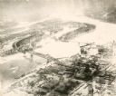
| Date: | 1955 |
|---|---|
| Description: | Aerial view of river and town from a military airplane. |

| Date: | 1953 |
|---|---|
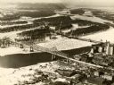
| Description: | Aerial view of La Crosse and the Mississippi River. In the foreground is the new bridge as of 1953. |
| Date: | 1935 |
|---|---|
| Description: | An aerial view of La Crosse and the Mississippi River with the bridge drawn in to show what the finished product would look like. |

| Date: | 1940 |
|---|---|
| Description: | Aerial view of the bridge spanning the Mississippi River in La Crosse. |
| Date: | 09 1939 |
|---|---|
| Description: | View from shoreline towards the bridge over the Mississippi River in La Crosse. |
| Date: | 1891 |
|---|---|
| Description: | A painting of the new (as of 1891) bridge over the Mississippi River in La Crosse. The bridge was built by the Clinton Bridge Co. Captions read: "North sid... |
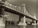
| Date: | 1940 |
|---|---|
| Description: | The bridge spanning the Mississippi River in La Crosse. |
| Date: | 1905 |
|---|---|
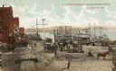
| Description: | View from the top of a railroad car on railroad tracks along the Mississippi River shoreline. Ships are along the shoreline on the right, and railroad trac... |
| Date: | 1900 |
|---|---|
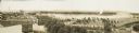
| Description: | Four-panel Panoramic view of La Crosse. Indentifiable businesses in view include: J. Hogan Wholesale Grocer, T.H. Spence Drug Co., Union Refrigerator Trans... |
| Date: | |
|---|---|
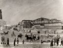
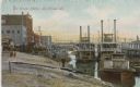
| Description: | Harbor full of steamboats. The shoreline is bustling with people walking amidst the buildings, piers and bridges. Caption reads: "La Crosse Harbor, La Cros... |
| Date: | 1998 |
|---|---|
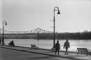
| Description: | A couple walking along the riverfront in winter, with a bridge across the Mississippi in the background. |

| Date: | 11 17 2004 |
|---|---|
| Description: | Opening day for the new bridge named "Cameron Avenue Bridge." |

| Date: | 1873 |
|---|---|
| Description: | A map that covers parts of Winona and Houston Counties, Minnesota and La Crosse County, Wisconsin, showing the proposed railroad routes, constructed rail l... |

| Date: | 1900 |
|---|---|
| Description: | This map of La Crosse shows twenty wards, some rural lots with acreages, streets, railroads, depots, bridges, cemeteries, parks, schools, islands, and the ... |

| Date: | 1872 |
|---|---|
| Description: | This map is pencil, ink, and watercolor on paper. Shown on the map is the elevation and profile of La Crescent Bottoms, Mt. Vernon Street line, 13th Street... |

| Date: | 1900 |
|---|---|
| Description: | The map is watercolor, pencil, and ink on tracing cloth and shows plats of both cities, local streets, railroads, mills, township divisions, bridges, and p... |
If you didn't find the material you searched for, our Library Reference Staff can help.
Call our reference desk at 608-264-6535 or email us at:
