 Filter: Categories of Wisconsin Historical Images
Filter: Subject of Bridges
Filter: Subject of clock towers
Filter: Categories of Wisconsin Historical Images
Filter: Subject of Bridges
Filter: Subject of clock towers
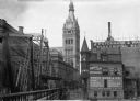
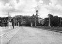
| Date: | 1895 |
|---|---|
| Description: | A bridge crosses the Milwaukee River on Oneida Street, now known as Wells Street, looking toward the City Hall tower. |

| Date: | 08 23 1913 |
|---|---|
| Description: | Elevated view looking east from W. Wells street across the Milwaukee River. The E. Wells power plant (with arrow), Pabst Theater, and City Hall are on the ... |

| Date: | 1939 |
|---|---|
| Description: | Wells Street Bridge occupies the bottom center of the image, with City Hall in the center background. Three men are walking on the bridge. |
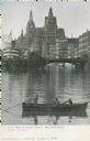
| Date: | |
|---|---|
| Description: | Hand-colored view from the water. Buildings are in the background, a boat and bridge are in the center. A small boat with people in it are in the foregroun... |
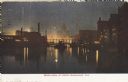
| Date: | 1909 |
|---|---|
| Description: | Railroad bridge over river and buildings at night. In the distance is a building with a clock tower. Caption reads: "River View, at Night, Milwaukee, Wis." |
| Date: | 1940 |
|---|---|
| Description: | View from the Wisconsin Avenue Bridge. A building on the left has a large sign for Gimbel's on its roof. Beyond the river in the background are two large s... |
| Date: | 1935 |
|---|---|
| Description: | Down the road and across the bridge from the theatre. Iron work on the bridge obstructs the view of the theatre. Cars are crossing the bridge, and pedestri... |
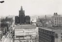
| Date: | 1920 |
|---|---|
| Description: | Elevated view over roofs, with the Milwaukee River in the background. |
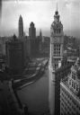
| Date: | 1947 |
|---|---|
| Description: | Numerous cars driving on what appears to be the Michigan Avenue Bridge (later renamed DuSable Bridge) in front of the Wrigley and Tribune buildings. There ... |
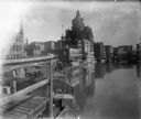
| Date: | 1898 |
|---|---|
| Description: | View from pier or dock of buildings along the Milwaukee River, including a building with a clock tower. Signage on brick exteriors reads "J.C. Iverson Co. ... |
| Date: | |
|---|---|
| Description: | Street-level view of the Central Moravian Church from an adjacent bridge lined with stone balustrades and wide sidewalks. A work crew is at the intersectio... |
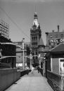
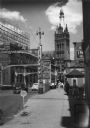
| Date: | 1936 |
|---|---|
| Description: | View from bridge of City Hall at North Water, North Market, and East Wells Streets, and East Kilbourn Avenue. |
| Date: | |
|---|---|
| Description: | Exterior view of the manual training buildings at the Stout Institute (now the University of Wisconsin-Stout) seen from across the campus lawn. The two bri... |

| Date: | |
|---|---|
| Description: | Westward view of Sturton Street, a dirt road lined with storefronts. Automobiles and horse-drawn carriages are parked along the street. On the right a man... |
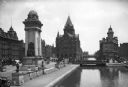
| Date: | |
|---|---|
| Description: | View of Masonic Park featuring the Erie Canal and the Soldiers and Sailors Monument, dedicated in 1909. The Empire House can be seen at left, constructed i... |
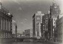
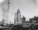
| Date: | |
|---|---|
| Description: | Elevated view of the business district and skyline. The Wrigley Building and clock tower stands in the foreground; it was built in 1920 by William Wrigley ... |

| Date: | 1914 |
|---|---|
| Description: | Scene of destroyed and burned out buildings after the Russian occupation. Handwritten at bottom right: "Niedenburg." |

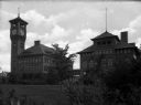
| Date: | |
|---|---|
| Description: | Central High School and Stout Manual Training School connected by pedestrian bridge. Two men are walking on the lawn towards the buildings. Caption reads: ... |
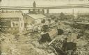
| Date: | 07 23 1912 |
|---|---|
| Description: | Text on front reads: "Below the High Bridge After the Flood. Wausau, Wisconsin." Railroad cars were swept away when dams at Brokaw and Merrill failed on th... |
If you didn't find the material you searched for, our Library Reference Staff can help.
Call our reference desk at 608-264-6535 or email us at: