 Filter: Categories of Wisconsin Historical Images
Filter: Subject of Bridges
Filter: Subject of business
Filter: Categories of Wisconsin Historical Images
Filter: Subject of Bridges
Filter: Subject of business

| Date: | 1890 |
|---|---|
| Description: | Bird's-eye map of Beloit with insets of Williams Engine Works, Eclipse Wind Engine Co., and John Foster & Co. Turtle Creek is in the lower section, and the... |

| Date: | 1891 |
|---|---|
| Description: | Bird's-eye map of Stevens Point, looking east, with an inset of the Water Works. Wisconsin River in foreground with fifty-three business locations identifi... |

| Date: | 1917 |
|---|---|
| Description: | This map shows streets, land owners, local businesses, the St. Louis River, and bridges. The maps reads: "Incorporated 1917." The back of the map includes ... |
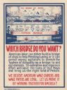
| Date: | 1918 |
|---|---|
| Description: | Poster featuring a cartoon illustration showing two different bridges. The first, labeled: "The Bridge of Ships," shows several large ships forming a bridg... |
If you didn't find the material you searched for, our Library Reference Staff can help.
Call our reference desk at 608-264-6535 or email us at: