 Filter: Categories of Wisconsin Historical Images
Filter: Subject of Bridges
Filter: Subject of bridges
Filter: Categories of Wisconsin Historical Images
Filter: Subject of Bridges
Filter: Subject of bridges

| Date: | 1872 |
|---|---|
| Description: | Birds-eye drawing of Eau Claire depicts street names and street locations, houses, trees, bridges, piers, canals, railroads, and the Chippewa and Eau Clair... |

| Date: | 1891 |
|---|---|
| Description: | Bird's-eye view of Eau Claire. |

| Date: | 1874 |
|---|---|
| Description: | Bird's-eye map of Grand Rapids. |

| Date: | 1877 |
|---|---|
| Description: | Bird's-eye map of Janesville on the Rock River. |

| Date: | 1893 |
|---|---|
| Description: | Bird's-eye map of Jefferson, looking north. Crayfish River at left and center, Rock River from upper center to bottom center, joins at left of center; thir... |

| Date: | 12 21 1882 |
|---|---|
| Description: | Bird's-eye map of Kaukauna, from the Appleton Post Annual Review. |

| Date: | 1874 |
|---|---|
| Description: | Bird's-eye map of Lodi, with inset of Public School. Includes index of churches and points of interest. |

| Date: | 1870 |
|---|---|
| Description: | Bird's-eye view of the city of Manitowoc with a population of 5,168 inhabitants as it appears in 1870, the year the village was granted a city charter by t... |
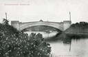
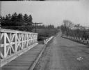
| Date: | |
|---|---|
| Description: | View from shoreline towards the Steensland Bridge with a boat and passengers passing beneath. Caption reads: "Steensland Bridge, Madison, Wis." |
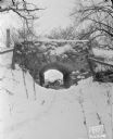
| Date: | 01 19 1945 |
|---|---|
| Description: | Stone bridge on Edgewood Drive, formerly an underpass for cows to access the lake. There are buildings further up the hill in the background. |
| Date: | 01 19 1945 |
|---|---|
| Description: | Looking towards the stone bridge on Edgewood Drive. |
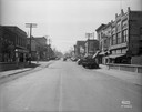
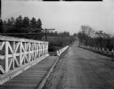
| Date: | 03 16 1939 |
|---|---|
| Description: | View of Main Street from the bridge. |
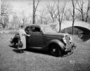
| Date: | 04 18 1935 |
|---|---|
| Description: | Miss Pyre standing next to a Ford V-8 coupe near a bridge at Tenney Park. A building with a tower is in the background, perhaps the Hausmann Brewing Compan... |
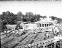
| Date: | 07 20 1931 |
|---|---|
| Description: | Construction of new overhead bridge — viaduct on US Highway 12 and 18 (West Broadway) across the North Western Railroad tracks near the Royal Airport. |
| Date: | 03 05 1931 |
|---|---|
| Description: | New stoplight on E. Washington Avenue bridge over the Yahara river, facing West. A truck is going over the bridge. On the other side of the bridge are indu... |

| Date: | 03 05 1931 |
|---|---|
| Description: | New stoplight on E. Washington Avenue bridge over the Yahara river, facing West. A truck is going over the bridge. On the other side of the bridge are indu... |
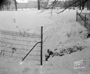
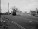
| Date: | 11 18 1930 |
|---|---|
| Description: | Trees cut down along US Hwy 12, South Beltline Highway, between John Nolen Drive & South Towne Drive. "Between the overhead grade crossing viaduct and the ... |
| Date: | 11 18 1930 |
|---|---|
| Description: | Trees cut down along US Hwy 12, South Beltline Highway, between John Nolen Drive & South Towne Drive. "Between the overhead grade crossing viaduct and the ... |
If you didn't find the material you searched for, our Library Reference Staff can help.
Call our reference desk at 608-264-6535 or email us at:

