 Filter: Categories of Wisconsin Historical Images
Filter: Subject of Bridges
Filter: Subject of breweries
Filter: Categories of Wisconsin Historical Images
Filter: Subject of Bridges
Filter: Subject of breweries
| Date: | |
|---|---|
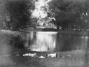
| Description: | Two boys lying on the grass asleep in Tenney Park near the lagoon with a hat on the ground between them. The Sherman Avenue bridge and the Hausmann Brewery... |
| Date: | 1904 |
|---|---|
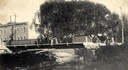
| Description: | View across Yahara River towards a group of people on the Sherman Avenue Bridge, with the old malt house in the background. |

| Date: | 1882 |
|---|---|
| Description: | This map of Cedarburg is a bird's-eye map with an inset of Cedarburg Brewery. Relief is shown pictorially and the map includes an index to buildings. |

| Date: | 1878 |
|---|---|
| Description: | Bird's-eye map of Chilton with insets of points of interest, including P.H. Becker's Brewery, Chilton House, and Gutheil's Block. |

| Date: | 1900 |
|---|---|
| Description: | Elevated view of the brewery dwarfed by the overhead bluffs. The brewery was built by William Schmitz. George Scheibl ran the brewery from 1899 until his d... |

| Date: | 1870 |
|---|---|
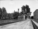
| Description: | View from along right side of bridge of Milwaukee Street looking east in Janesville. The Myers House is located at the top of the hill. There is a sign for... |
| Date: | 1900 |
|---|---|
| Description: | View from bridge towards Hartig's Brewery on the left. Caption reads: "Greetings from Watertown, Wis." |

| Date: | |
|---|---|
| Description: | Southside Brewery, formerly the Melm's Brewery. A bridge, a boat, a river, several small buildings, and horse-drawn vehicles are in the foreground. Caption... |

| Date: | |
|---|---|
| Description: | View of Rock River from Main Street Bridge. Hartig Brewery, opened in 1884, is along the right shoreline. |
| Date: | 1900 |
|---|---|
| Description: | A view of the back of the brewery, taken from a bridge. A man walks across the bridge, away from the camera. |

| Date: | 1885 |
|---|---|
| Description: | A detail of a Sanborn map including Catfish Creek and Westport Road by Lake Mendota. |

| Date: | |
|---|---|
| Description: | View across lawn and the Yahara River towards the Hausmann Brewing Company's Malt House in the center background. On the right is the Yahara River bridge. ... |
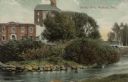
| Date: | 1911 |
|---|---|
| Description: | View from shoreline across river towards an industrial building near the Yahara River. A bridge is behind trees and bushes on the right. Caption reads: "Te... |
| Date: | 1955 |
|---|---|
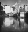
| Description: | Industries along the Milwaukee River, one of which is the Schlitz Brewery. |

| Date: | 1892 |
|---|---|
| Description: | A Sanborn fire insurance map of Sauk City which was drawn up in 1892. |

| Date: | 1915 |
|---|---|
| Description: | A Sanborn fire insurance map of Sauk City created in 1915. |
If you didn't find the material you searched for, our Library Reference Staff can help.
Call our reference desk at 608-264-6535 or email us at: