Filter: Categories of Wisconsin Historical Images
Filter: Subject of Bridges
Filter: County of Dane
Filter: Year of 1800-1899
Filter: Categories of Wisconsin Historical Images
Filter: Subject of Bridges
Filter: County of Dane
Filter: Year of 1800-1899

| Date: | 1876 |
|---|---|
| Description: | View of a farmstead with fences, haystacks and a wooden outbuilding. Two men are posing on top of McCord Rock, one of them saluting with his hat. Another ... |

| Date: | 1874 |
|---|---|
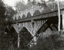
| Description: | Elevated view from hill of Clinton, now Rockdale. Three men are in the middle distance, looking east across Koshonong Creek towards a mill dam, bridge and ... |
| Date: | 1890 |
|---|---|
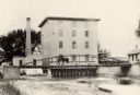
| Description: | View towards the mill on the Yahara River at the outlet of Lake Mendota. The mill was built in 1850 by Governor Farwell. A man is standing on the bridge wi... |
| Date: | 1897 |
|---|---|
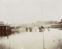
| Description: | Yahara River at the Steensland Bridge. A man stands on the bank. |

| Date: | 1894 |
|---|---|
| Description: | A young girl poses on a rustic wooden bridge in the woods. |

| Date: | 07 04 1898 |
|---|---|
| Description: | A man sits and a woman rests against a tree near a rustic bridge. Several bicycles are parked nearby as well. |
| Date: | 1895 |
|---|---|
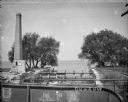
| Description: | View from bridge towards a tall smokestack standing on the left side of the Yahara River where it is flowing out of Lake Mendota. Remnants of the foundatio... |

| Date: | 1885 |
|---|---|
| Description: | A detail of a Sanborn map including Catfish Creek and Westport Road by Lake Mendota. |
If you didn't find the material you searched for, our Library Reference Staff can help.
Call our reference desk at 608-264-6535 or email us at: