 Filter: Categories of Wisconsin Historical Images
Filter: Subject of Bridges
Filter: County of Brown
Filter: Year of 1800-1899
Filter: Categories of Wisconsin Historical Images
Filter: Subject of Bridges
Filter: County of Brown
Filter: Year of 1800-1899

| Date: | 1867 |
|---|---|
| Description: | Bird's-eye map of Green Bay and Fort Howard, Brown Co., depicts street names and street layouts, houses, trees, and the East River. A reference key at the ... |
| Date: | 1889 |
|---|---|
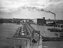
| Description: | Elevated view of bridge crossing the wide Fox River, with the paper mill on the far side of the river, and a horse-drawn cart approaching the near side. |

| Date: | 1870 |
|---|---|
| Description: | Five piece panoramic view of the Green Bay waterfront area. |
| Date: | 1889 |
|---|---|
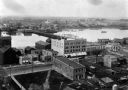
| Description: | Elevated view of Washington Street and the Fox River and buildings nearby. |
| Date: | 1865 |
|---|---|
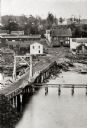
| Description: | Elevated view of a bridge and logging debris around residential homes. |

| Date: | 1893 |
|---|---|
| Description: | Bird’s-eye view of Depere looking North. Includes illustrations and an index to points of interest. |

| Date: | 1875 |
|---|---|
| Description: | Elevated view over De Pere. In the foreground is the De Pere News Office and Post Office building. Behind it people are walking on the bridge over the Fox ... |
| Date: | 1889 |
|---|---|
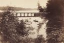
| Description: | View from shoreline looking down on Mud Creek, about two miles above De Pere, showing small bridge and a man in a rowboat. |

| Date: | 1875 |
|---|---|
| Description: | Elevated view of several buildings, with bridge and railroad tracks, and the Fox River. In the foreground on the right is the Commercial House, with three ... |
If you didn't find the material you searched for, our Library Reference Staff can help.
Call our reference desk at 608-264-6535 or email us at:
