Filter: Categories of Wisconsin Historical Images
Filter: Subject of Bridges
Filter: Community of Wausau
Filter: Categories of Wisconsin Historical Images
Filter: Subject of Bridges
Filter: Community of Wausau
| Date: | 1916 |
|---|---|
| Description: | Water churns under a railroad bridge as the spring thaw swells the Wisconsin River. |

| Date: | 1879 |
|---|---|
| Description: | This map is a bird's-eye view of Wausau, the County Seat of Marathon County. The map features an index of points of interest. |
| Date: | 1928 |
|---|---|
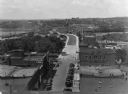
| Description: | Elevated view of the main street with the Wisconsin River in the top left corner. The street just outside the Hall Garage Company is lined with cars. |
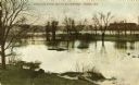
| Date: | 07 1912 |
|---|---|
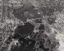
| Description: | Elevated view across the Wisconsin River, showing the wreckage left by the disastrous flood of July 24, 1912. A power dam on the Wisconsin River above Waus... |
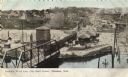
| Date: | 1905 |
|---|---|
| Description: | View down unpaved road towards Stroller's Bridge, with the city and a public building in the background. Caption reads: "Stroller's Bridge, Wausau, Wis." |
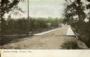
| Date: | 1909 |
|---|---|
| Description: | View from shoreline towards Stroller's Bridge. Caption reads: "Strollers Bridge and the Old Wisconse, Wausau, Wis." |
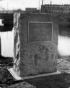
| Date: | 1929 |
|---|---|
| Description: | View of the George Stevens marker with the Wisconsin Auto Supply Company in the background and the Wisconsin River. |
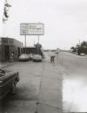
| Date: | 1983 |
|---|---|
| Description: | The approach to the Scott Street Bridge in Wausau, with the Wausau Cab Co. building and a large sign advertising the First American Bank, a "tower of stren... |

| Date: | 10 18 1968 |
|---|---|
| Description: | View looking north under Wausau's Scott Street (also State Highway H 29 and Business 51) Bridge, with a railroad bridge in the foreground and the warehouse... |
| Date: | 1905 |
|---|---|
| Description: | Elevated view of the railroad station looking west. A bridge over the river is in the foreground, and a large water tower is across the railroad tracks on ... |
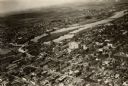
| Date: | 1925 |
|---|---|
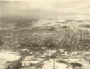
| Description: | Aerial view of buildings in the downtown area. |

| Date: | 1910 |
|---|---|
| Description: | View of the Falls Bridge and surrounding buildings. Caption reads: "Falls Bridge, Bet. East and West Sides, Wausau, Wis." |
| Date: | 1918 |
|---|---|
| Description: | View of the bridge over the Wisconsin River at Big Bull Falls, seen at low water. |
| Date: | 1939 |
|---|---|
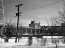
| Description: | An exterior view of the Cereal Mills Company, located at 112-118 West Scott Street. A railroad and a highway bridge are in the foreground. |

| Date: | |
|---|---|
| Description: | "Peavy Falls Group" of men and boys posed on bank of river. There is a man in a canoe in the river, and a footbridge in the background. |

| Date: | |
|---|---|
| Description: | View up the Wisconsin River showing the dam and a bridge. A streetcar and a small group of people are gathered on one end. |

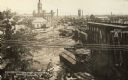
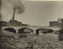
| Date: | 1912 |
|---|---|
| Description: | Aftermath of a flood. Debris of railroad ties, tracks, and cars are scattered beneath a bridge. |

| Date: | 1916 |
|---|---|
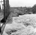
| Description: | Water of Big Bull Falls or the Wisconsin River rapidly flows underneath two railroad bridges. Pedestrians cross the bridges while peering over at the over... |
If you didn't find the material you searched for, our Library Reference Staff can help.
Call our reference desk at 608-264-6535 or email us at: