 Filter: Categories of Wisconsin Historical Images
Filter: Subject of Bridges
Filter: Community of Oneida
Filter: Categories of Wisconsin Historical Images
Filter: Subject of Bridges
Filter: Community of Oneida
| Date: | |
|---|---|
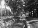
| Description: | View of a tree-lined waterway that runs through a residential area. The street and commercial buildings are on the left, and there are footbridges from the... |

| Date: | 1908 |
|---|---|
| Description: | This 1908 map shows the township and range grid, sections, towns, villages, railroads, bridges, lakes, streams, rapids, and state-owned lands in Oneida Cou... |
If you didn't find the material you searched for, our Library Reference Staff can help.
Call our reference desk at 608-264-6535 or email us at: