 Filter: Categories of Wisconsin Historical Images
Filter: Subject of Bridges
Filter: Community of Green Bay
Filter: Year of 1800-1899
Filter: Categories of Wisconsin Historical Images
Filter: Subject of Bridges
Filter: Community of Green Bay
Filter: Year of 1800-1899

| Date: | 1867 |
|---|---|
| Description: | Bird's-eye map of Green Bay and Fort Howard, Brown Co., depicts street names and street layouts, houses, trees, and the East River. A reference key at the ... |

| Date: | 1870 |
|---|---|
| Description: | Five piece panoramic view of the Green Bay waterfront area. |
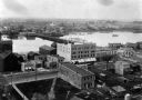
| Date: | 1889 |
|---|---|
| Description: | Elevated view of Washington Street and the Fox River and buildings nearby. |
If you didn't find the material you searched for, our Library Reference Staff can help.
Call our reference desk at 608-264-6535 or email us at: