 Filter: Categories of Wisconsin Historical Images
Filter: Subject of Bridges
Filter: Community of Green Bay
Filter: Subject of architecture
Filter: Categories of Wisconsin Historical Images
Filter: Subject of Bridges
Filter: Community of Green Bay
Filter: Subject of architecture

| Date: | 1867 |
|---|---|
| Description: | Bird's-eye map of Green Bay and Fort Howard, Brown Co., depicts street names and street layouts, houses, trees, and the East River. A reference key at the ... |
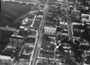
| Date: | 1920 |
|---|---|
| Description: | Aerial view of the commercial district on the east side of the Fox River. Left to right: Hurlbut Coal Company; suggested location for small terminal; Main... |
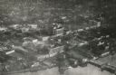
| Date: | 1924 |
|---|---|
| Description: | Aerial view of Green Bay's commercial district, bridges, and water. |
| Date: | 1925 |
|---|---|
| Description: | Aerial view of Green Bay, including the Jorgensen-Blesch Company building and two bridges. |
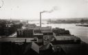
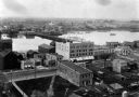
| Date: | 1910 |
|---|---|
| Description: | Elevated view over rooftops towards the Fox River looking south, with factories and a smokestack in the foreground. |
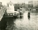
| Date: | 1935 |
|---|---|
| Description: | Harbor view along side of bridge, with people strolling around the bay, cars parked in a lot, and buildings with companies that export and import merchandi... |
| Date: | 1889 |
|---|---|
| Description: | Elevated view of Washington Street and the Fox River and buildings nearby. |

| Date: | 1906 |
|---|---|
| Description: | View from Fox River of chimneys, buildings, and boat. Caption reads: "River Front, Green Bay, Wis." |
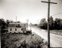
| Date: | 1920 |
|---|---|
| Description: | Elevated view of the outskirts of an unidentified town in the vicinity of Green Bay. The sign painted on the roof of the building on the left reads: "Beer ... |
| Date: | |
|---|---|
| Description: | Aerial view of Green Bay, and the Fox River headed toward the bay. Commercial and industrial buildings are on the right bank, and residential neighborhoods... |

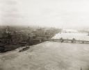
| Date: | |
|---|---|
| Description: | Elevated view of the Fox River at Green Bay. Warehouses and factories are along the riverfront, and a drawbridge is spanning the river in the background. |
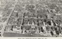
| Date: | 1956 |
|---|---|
| Description: | Caption reads: "Aerial View, Downtown Section, Green Bay, Wis." Text on reverse reads: "This aerial view shows the downtown district of the east side of ... |
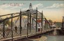
| Date: | |
|---|---|
| Description: | Illustrated postcard of an iron bridge over the Fox River with pedestrians crossing. The street on the far side is lined with businesses. Caption reads: "E... |

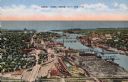
| Date: | |
|---|---|
| Description: | Colorized postcard of the Fox River and the buildings along the waterfront. The bridge in the foreground has a movable center section. Caption reads: "Bird... |

| Date: | |
|---|---|
| Description: | Color postcard of downtown Green Bay and bridges spanning the Fox River. The Walnut Street Bridge is in the foreground. A 4-level parking garage is on the ... |

| Date: | 1941 |
|---|---|
| Description: | Elevated view of a highway bridge spanning the Fox River. Caption reads: "Claude Allouez Bridge at De Pere, Near Green Bay, Wis." |
If you didn't find the material you searched for, our Library Reference Staff can help.
Call our reference desk at 608-264-6535 or email us at: