 Filter: Categories of Wisconsin Historical Images
Filter: Subject of Breweries
Filter: Year of 1800-1899
Filter: Categories of Wisconsin Historical Images
Filter: Subject of Breweries
Filter: Year of 1800-1899

| Date: | 1859 |
|---|---|
| Description: | This map show plats including plat names, plat numbers, and some lot owner's names. Relief is shown by hachures. The map includes line drawings of Juneau B... |

| Date: | 1886 |
|---|---|
| Description: | This map has relief shown by hachures and includes a list of plats in order of date of record, laws which vacate plats, plats not shown as upon the county ... |
| Date: | 1886 |
|---|---|
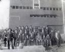
| Description: | Outdoor group portrait of a crowd visiting Greenwood Brewery. Individuals pictured include: First row, left to right: Anton Novy, Edward McDonough, Frank R... |

| Date: | 1883 |
|---|---|
| Description: | This map shows ward boundaries, names of additions, streets, bridges, mills, schools, religious buildings, businesses, hotels, railroads, factories, brewer... |

| Date: | 1883 |
|---|---|
| Description: | View across State Street towards two buildings, with, on the left, the Hess & Schmitz Livery Boarding and Sale Stable, and on the right the Empire Brewery.... |
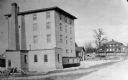
| Date: | 1850 |
|---|---|
| Description: | A grist mill on the Yahara River at the outlet of Lake Mendota. The mill, called Farwell's Madison Mills was built in 1850 by Governor Farwell. The origina... |

| Date: | 10 1884 |
|---|---|
| Description: | A Sanborn map of Watertown, including the City Brewery and the Rock River. |
| Date: | 1895 |
|---|---|
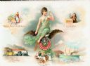
| Description: | Composite art page from a booklet of verses about Miller Beer. Images include a woman at top left who is perhaps working with hops, captioned: "Original Mi... |

| Date: | 1891 |
|---|---|
| Description: | View of the George Ruder Brewing Company. A group of men and a dog are posing near an entrance on the side of the brick building. A man is on a horse-drawn... |

| Date: | 1896 |
|---|---|
| Description: | View down street towards the George Walter Brewing Company. A large group of people are posing on the street with horse-drawn carriages and horse-drawn wag... |

| Date: | 1860 |
|---|---|
| Description: | Inset from Map of Dodge County. Caption reads: "Farmer's Brewery, (Beaver Dam) Aman & Schutte, Proprs." A sign on the building reads: "Farmer's Brewery by ... |

| Date: | 1892 |
|---|---|
| Description: | A Sanborn fire insurance map of Sauk City which was drawn up in 1892. |

| Date: | 1891 |
|---|---|
| Description: | The index page of a Sanborn Map of Stevens Point. |

| Date: | 1891 |
|---|---|
| Description: | Page 13 of a Sanborn map of Stevens Point. |
If you didn't find the material you searched for, our Library Reference Staff can help.
Call our reference desk at 608-264-6535 or email us at: