 Filter: Categories of Wisconsin Historical Images
Filter: Subject of Breweries
Filter: Year of 1800-1899
Filter: Subject of streets
Filter: Categories of Wisconsin Historical Images
Filter: Subject of Breweries
Filter: Year of 1800-1899
Filter: Subject of streets

| Date: | 1884 |
|---|---|
| Description: | A sign for Fauerbach's Brewery depicting a young woman and the brewery. |
| Date: | 1888 |
|---|---|
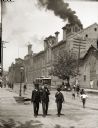
| Description: | Exterior of Schlitz Brewing Company with two men and a boy in suits and hats in the foreground. |
| Date: | 1873 |
|---|---|
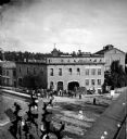
| Description: | Elevated view of employees, along with young children, posed around a wagon loaded with barrels of beer in front of Hausmann's Capital Brewery at the corne... |

| Date: | 1898 |
|---|---|
| Description: | Bird's-eye map of Milwaukee with prominent streets and buildings identified. Taken from City Hall Tower. |

| Date: | 1878 |
|---|---|
| Description: | Bird's-eye map of Chilton with insets of points of interest, including P.H. Becker's Brewery, Chilton House, and Gutheil's Block. |

| Date: | 1880 |
|---|---|
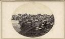
| Description: | Bird's-eye map over the Mississippi River of Fountain City. Paddle steamers and steamboats are on the river, and bluffs are in the background. |
| Date: | 1862 |
|---|---|
| Description: | John S. Fuller took this image of the third Wisconsin State Capitol (the second in Madison), from Governor Farwell's Octagon House, probably early in 1862.... |

| Date: | 1870 |
|---|---|
| Description: | View from along right side of bridge of Milwaukee Street looking east in Janesville. The Myers House is located at the top of the hill. There is a sign for... |

| Date: | 09 1884 |
|---|---|
| Description: | Sanborn map of Fort Atkinson including Barrie, Germany, and North Water Streets. |

| Date: | 1859 |
|---|---|
| Description: | This map show plats including plat names, plat numbers, and some lot owner's names. Relief is shown by hachures. The map includes line drawings of Juneau B... |

| Date: | 1886 |
|---|---|
| Description: | This map has relief shown by hachures and includes a list of plats in order of date of record, laws which vacate plats, plats not shown as upon the county ... |

| Date: | 1883 |
|---|---|
| Description: | This map shows ward boundaries, names of additions, streets, bridges, mills, schools, religious buildings, businesses, hotels, railroads, factories, brewer... |

| Date: | 1883 |
|---|---|
| Description: | View across State Street towards two buildings, with, on the left, the Hess & Schmitz Livery Boarding and Sale Stable, and on the right the Empire Brewery.... |

| Date: | 10 1884 |
|---|---|
| Description: | A Sanborn map of Watertown, including the City Brewery and the Rock River. |

| Date: | 1896 |
|---|---|
| Description: | View down street towards the George Walter Brewing Company. A large group of people are posing on the street with horse-drawn carriages and horse-drawn wag... |

| Date: | 1892 |
|---|---|
| Description: | A Sanborn fire insurance map of Sauk City which was drawn up in 1892. |

| Date: | 1891 |
|---|---|
| Description: | The index page of a Sanborn Map of Stevens Point. |

| Date: | 1891 |
|---|---|
| Description: | Page 13 of a Sanborn map of Stevens Point. |
If you didn't find the material you searched for, our Library Reference Staff can help.
Call our reference desk at 608-264-6535 or email us at: