 Filter: Categories of Wisconsin Historical Images
Filter: Subject of Blueprints
Filter: Categories of Wisconsin Historical Images
Filter: Subject of Blueprints

| Date: | |
|---|---|
| Description: | Side elevation, north and south view of the recitation hall and administration building for Pyengyang Christian Academy in Korea. |

| Date: | |
|---|---|
| Description: | Back elevation, west view of the recitation hall and administration building for Pyengyang Christian Academy in Korea. |

| Date: | |
|---|---|
| Description: | A floor plan for the first floor of the recitation hall and administration building for Pyengyang Christian Academy in Korea. |

| Date: | |
|---|---|
| Description: | A floor plan including classrooms and the chapel for the recitation hall and administration building for Pyengyang Christian Academy in Korea. |

| Date: | |
|---|---|
| Description: | A floor plan for the basement of the recitation hall and administration building for Pyengyang Christian Academy in Korea. |

| Date: | 1926 |
|---|---|
| Description: | This blueprint map shows the harbor at Kenosha, also showing buildings surrounding the harbor, roads, and railroads. Original caption in red states: "Areas... |

| Date: | 1912 |
|---|---|
| Description: | This blueprint map with color manuscript annotations shows an area now known as the Forest Hills Golf Club. Includes labels for land parcels, blocks and ro... |

| Date: | 1902 |
|---|---|
| Description: | This blueprint map shows land parcels, parks, blocks, and streets in the region north to Atwood Avenue, south to Lake Monona, west to Evergreen Avenue, and... |

| Date: | 1905 |
|---|---|
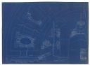
| Description: | This blueprint map shows buildings and roads on Bascom Hill. University Avenue, Park street, Charter Street, and Lincoln Drive are labeled. Lake Mendota is... |

| Date: | 1910 |
|---|---|
| Description: | This blueprint plat map shows the plan of lots and streets on a Madison hill south of Lake Monona. Includes annotations showing land prices in pencil. |

| Date: | 1914 |
|---|---|
| Description: | This blueprint map includes manuscript annotations in red and shows number of acres and dates of acquisition (1905-1914) of each parcel of land, as well as... |

| Date: | 1926 |
|---|---|
| Description: | This blueprint map shows Manitowoc Harbor with depths represented by soundings. The upper right corner includes a "Description of Bench Marks". The map als... |

| Date: | 1920 |
|---|---|
| Description: | This blue line print map shows the forks of the Montreal River. The East Branch and West Branch are labeled, with arrows showing the flow of the river. |

| Date: | 1890 |
|---|---|
| Description: | This blue line print map created sometime between 1886 and 1916 covers parts of northern Taylor County and eastern Sawyer and Rusk counties Each of the tow... |

| Date: | 1903 |
|---|---|
| Description: | This blue line print shows quartzite areas, mines, railroads, and roads. The map covers townships 11-13 north, ranges 4-8 east, in parts of Sauk and Columb... |

| Date: | 1920 |
|---|---|
| Description: | This blue print map shows landownership between 1913 and 1916, topography, railroads, and roads. The map covers the vicinity of Perrot State Park. |

| Date: | |
|---|---|
| Description: | A male office worker wearing a white shirt and necktie is sitting cross-legged on a blueprint drawing on the factory floor at Gisholt Machine Company. The ... |

| Date: | 1905 |
|---|---|
| Description: | This blueprint map includes manuscript annotations in red showing land of Home Realty Co., Hon. Geo. B. Burrows, and A.O. Fox Industrial. |

| Date: | 1873 |
|---|---|
| Description: | This blueprint map shows water depths by soundings and isolines. To the top left is Duluth, Minnesota. To the bottom right is Superior City, Wisconsin. The... |
| Date: | 1909 |
|---|---|
| Description: | Elevations and plan, end of barrel vault, main stairs and ornament, crowning pediment. |
If you didn't find the material you searched for, our Library Reference Staff can help.
Call our reference desk at 608-264-6535 or email us at: