 Filter: Categories of Wisconsin Historical Images
Filter: Subject of Blueprints
Filter: Year of 1900-1999
Filter: Year of 1910-1919
Filter: Categories of Wisconsin Historical Images
Filter: Subject of Blueprints
Filter: Year of 1900-1999
Filter: Year of 1910-1919

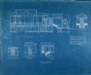
| Date: | 07 13 1910 |
|---|---|
| Description: | First floor plan of the Chicago residence of Nettie Fowler McCormick, widow of Cyrus Hall McCormick. The plan presents alterations and additions to the ori... |
| Date: | 07 13 1910 |
|---|---|
| Description: | Blueprint of the west elevation of the Chicago residence of Nettie Fowler McCormick, widow of Cyrus Hall McCormick. The plan presents alterations and addit... |
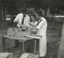
| Date: | 08 1919 |
|---|---|
| Description: | Two women and one man, probably rural school teachers, are standing outdoors near a work bench, reviewing the blueprints to construct a nail box. |

| Date: | 1910 |
|---|---|
| Description: | This blue print map shows original lakes, area to be covered by Chippewa Flowage (flow-lines for contours 1310 and 1315), dam sites, roads, and buildings. |

| Date: | 1912 |
|---|---|
| Description: | This blueprint manuscript map shows selected buildings, roads, and the Peshtigo River. |

| Date: | 1912 |
|---|---|
| Description: | This manuscript blueprint map shows numbered buildings and manuscript annotations. Lake Mendota and streets are labeled. |

| Date: | 1910 |
|---|---|
| Description: | This manuscript blueprint map shows building outlines in vicinity of North Hall and Science Hall, retaining walls, and walkways. |

| Date: | 1912 |
|---|---|
| Description: | This manuscript blueprint map shows land conditions for future construction development on the University of Wisconsin-Madison campus. It highlights roads ... |

| Date: | 1915 |
|---|---|
| Description: | This manuscript blueprint map oriented with north to the upper right. The map includes street names, certifications, and registration. Streets left to righ... |

| Date: | 11 1915 |
|---|---|
| Description: | This manuscript blueprint shows streets and includes certifications and registration. The streets running left to right are: Wenonah Drive, Wanda Place, Na... |

| Date: | 1912 |
|---|---|
| Description: | This blueprint map with color manuscript annotations shows an area now known as the Forest Hills Golf Club. Includes labels for land parcels, blocks and ro... |

| Date: | 1910 |
|---|---|
| Description: | This blueprint plat map shows the plan of lots and streets on a Madison hill south of Lake Monona. Includes annotations showing land prices in pencil. |

| Date: | 1914 |
|---|---|
| Description: | This blueprint map includes manuscript annotations in red and shows number of acres and dates of acquisition (1905-1914) of each parcel of land, as well as... |
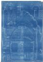
| Date: | 03 1911 |
|---|---|
| Description: | Sectional elevation, superstructure, central section. |
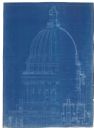
| Date: | 08 1911 |
|---|---|
| Description: | Elevations, sections, details of interior of dome. Central portion. |

| Date: | 10 1910 |
|---|---|
| Description: | Elevations, sections, plans of central portion and corners. |
| Date: | 07 1910 |
|---|---|
| Description: | Furniture details of desks, chairs and tables. |
| Date: | 08 1910 |
|---|---|
| Description: | Furniture details of desks, chairs, tables, davenports and bookcases. |

| Date: | 1912 |
|---|---|
| Description: | Booklet with plans and specifications by the IHC Service Bureau. Includes "Suggestions For Building a Farm House", and 10 pages of blueprints. |

| Date: | 1912 |
|---|---|
| Description: | Booklet with plans and specifications by the IHC Service Bureau. |
If you didn't find the material you searched for, our Library Reference Staff can help.
Call our reference desk at 608-264-6535 or email us at: