 Filter: Categories of Wisconsin Historical Images
Filter: Subject of Blueprints
Filter: Year of 1900-1999
Filter: Year of 1900-1909
Filter: Categories of Wisconsin Historical Images
Filter: Subject of Blueprints
Filter: Year of 1900-1999
Filter: Year of 1900-1909
| Date: | 1900 |
|---|---|
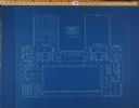
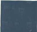
| Description: | Floor plan for the second floor library and offices of the State Historical Society building designed by architects Ferry & Clas and constructed in 1900. F... |
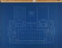
| Date: | 1900 |
|---|---|
| Description: | Floor plan for the third floor of the State Historical Society building designed by architects Ferry & Clas and constructed in 1900. |
| Date: | 1900 |
|---|---|
| Description: | Sheet #26 of the plans for the State Historical Society building prepared by architects Ferry & Clas, showing longitudinal sections of corridor 142 and Roo... |

| Date: | 1900 |
|---|---|
| Description: | Sheet # 25 of the plans submitted by architects Ferry & Clas for the construction of the State Historical Society building, showing longitudinal sections o... |
| Date: | 1900 |
|---|---|
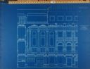
| Description: | Sheet #27 of the plans submitted by architects Ferry & Clas for the State Historical Society building showing a section of all four stories of the building... |
| Date: | 1900 |
|---|---|
| Description: | Sheets 21: Exterior section through the main loggia (Room 226) and portion of the east elevation, 1 1/2 bays of the loggia. |

| Date: | 1907 |
|---|---|
| Description: | Topographic map of the Wisconsin River done under direction of Daniel Meade for construction of the Kilbourn dam by the Southern Wisconsin Power Company. I... |

| Date: | 1900 |
|---|---|
| Description: | Blueprint of the stone seat, outside elevation of Gate "Y," rear of fountain at end of basin, and elevation of Gate "Z" for Stanley McCormick's Riven Rock ... |

| Date: | 1900 |
|---|---|
| Description: | Blueprint showing the elevation of Gate "X" for Stanley McCormick's Riven Rock estate at El Montecito, Santa Barbara, California. The blueprint shows a vie... |
| Date: | 1900 |
|---|---|
| Description: | Blueprint showing the mantles at Stanley McCormick's Riven Rock estate in El Montecito, Santa Barbara County, California. The architectural firm is identif... |

| Date: | 1900 |
|---|---|
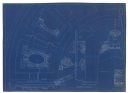
| Description: | This blue line print map shows land use, cables, U.S.L.S.S. walk and clearing, and front and rear range lights on the Porte des Morts Passage. Tree types a... |

| Date: | 1907 |
|---|---|
| Description: | This manuscript blueprint map shows land parcels pertaining to University Heights region in Madison, Wisconsin. Streets labeled included, University Avenue... |

| Date: | 1907 |
|---|---|
| Description: | This blueprint map shows a proposed plan for pleasure roads and reservation system. It also shows schools, cemeteries, old river channel, proposed bridge, ... |

| Date: | 1905 |
|---|---|
| Description: | This blueprint map shows rivers, land parcels, and streets. It also highlights selected public and industrial buildings. |

| Date: | 1902 |
|---|---|
| Description: | This blueprint map shows land parcels, parks, blocks, and streets in the region north to Atwood Avenue, south to Lake Monona, west to Evergreen Avenue, and... |

| Date: | 1905 |
|---|---|
| Description: | This blueprint map shows buildings and roads on Bascom Hill. University Avenue, Park street, Charter Street, and Lincoln Drive are labeled. Lake Mendota is... |

| Date: | 1903 |
|---|---|
| Description: | This blue line print shows quartzite areas, mines, railroads, and roads. The map covers townships 11-13 north, ranges 4-8 east, in parts of Sauk and Columb... |

| Date: | 1905 |
|---|---|
| Description: | This blueprint map includes manuscript annotations in red showing land of Home Realty Co., Hon. Geo. B. Burrows, and A.O. Fox Industrial. |
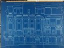
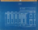
| Date: | 1909 |
|---|---|
| Description: | Elevations and plan, end of barrel vault, main stairs and ornament, crowning pediment. |
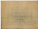
| Date: | 1907 |
|---|---|
| Description: | Sectional elevation, near west wall. |
If you didn't find the material you searched for, our Library Reference Staff can help.
Call our reference desk at 608-264-6535 or email us at: