 Filter: Categories of Wisconsin Historical Images
Filter: Subject of Blueprints
Filter: Subject of recreation
Filter: Categories of Wisconsin Historical Images
Filter: Subject of Blueprints
Filter: Subject of recreation

| Date: | 1927 |
|---|---|
| Description: | Blueprint-style map of Frost Woods on the shore of Lake Monona. The map indicates the locations of Indian mounds, an Indian camp, and various plants. There... |
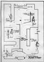
| Date: | 08 1948 |
|---|---|
| Description: | Floor plan of the Wisconsin Historical Society's "Story of Wisconsin" exhibit at the Wisconsin Centennial Exposition. |

| Date: | 1891 |
|---|---|
| Description: | This map shows soft marshland, water channels, solid ground, club boundary and shooting boxes. Big Lake, First Channel, Second Channel, Fout Mile Pond, Mal... |

| Date: | 1912 |
|---|---|
| Description: | This blueprint map with color manuscript annotations shows an area now known as the Forest Hills Golf Club. Includes labels for land parcels, blocks and ro... |
If you didn't find the material you searched for, our Library Reference Staff can help.
Call our reference desk at 608-264-6535 or email us at: