 Filter: Categories of Wisconsin Historical Images
Filter: Subject of Blueprints
Filter: Creator Name of Hardy-Ryan Abstract Co.
Filter: Subject of architecture
Filter: Categories of Wisconsin Historical Images
Filter: Subject of Blueprints
Filter: Creator Name of Hardy-Ryan Abstract Co.
Filter: Subject of architecture
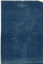
| Date: | 1927 |
|---|---|
| Description: | This blueprint map shows landownership around the lake. Water depths are shown by soundings; relief is shown by hachures. The map was originally created in... |
If you didn't find the material you searched for, our Library Reference Staff can help.
Call our reference desk at 608-264-6535 or email us at: