 Filter: Categories of Wisconsin Historical Images
Filter: Subject of Bird's-eye views
Filter: Year of 1900-1999
Filter: Community of Madison
Filter: Categories of Wisconsin Historical Images
Filter: Subject of Bird's-eye views
Filter: Year of 1900-1999
Filter: Community of Madison

| Date: | 1908 |
|---|---|
| Description: | Colored map showing a panoramic view of Madison in great detail. The Wisconsin State Capitol is located at the center, with Lake Mendota in the background ... |

| Date: | 1907 |
|---|---|
| Description: | Bird's-eye view of the University of Wisconsin-Madison campus looking northwest. Building at top of hill, to left of center is Bascom Hill (Main Hall) and... |

| Date: | 1949 |
|---|---|
| Description: | Color bird's-eye map of the University of Wisconsin-Madison as it was midcentury, with two co-eds, several photographs of campus landmarks around edges, an... |

| Date: | 1948 |
|---|---|
| Description: | Colored map with black and white photographic images in wedges at right and left sides. Map extends from Camp Randal stadium at bottom left corner, to Lake... |

| Date: | 1929 |
|---|---|
| Description: | Bird's-eye map of the University of Wisconsin-Madison on Lake Mendota. Black and white drawing with named streets and numbered buildings without location ... |

| Date: | 1910 |
|---|---|
| Description: | Bird's-eye view. Caption reads: "Madison, Wis. and the Four Lake Region." |
| Date: | 1901 |
|---|---|
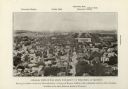
| Description: | Elevated view looking west down State Street towards the University of Wisconsin. Caption reads: "General View of the State University of Wisconsin, at Mad... |

| Date: | 1928 |
|---|---|
| Description: | An aerial view of the buildings and grounds of the Wisconsin Memorial Hospital, located at Farwell's Point. |

| Date: | 1917 |
|---|---|
| Description: | Bird's-eye view of the University of Wisconsin-Madison campus. |

| Date: | 1978 |
|---|---|
| Description: | Bird’s-eye view map. Shows Madison from the edge of Lake Monona stretching west. Above the map are clouds and in the distance is the edge of the world and ... |

| Date: | 1920 |
|---|---|
| Description: | This hand-colored bird's-eye-view map shows roads, parks, golf club, schools, buildings, landscaping, and part of Lake Wingra. |

| Date: | 1916 |
|---|---|
| Description: | Birds-eye view of the University of Wisconsin-Madison campus. The Armory (Red Gym), Science Hall and State Historical Society are in the foreground. Main H... |

| Date: | 1908 |
|---|---|
| Description: | Bird's-eye view showing Lake Mendota, Lake Monona, Lake Waubesa, Lake Wingra and Lake Kegonsa. Madison has only the isthmus developed, and there are settle... |

| Date: | 1928 |
|---|---|
| Description: | Birds-eye view showing Lake Mendota, Lake Monona, Lake Wingra, Lake Waubesa and Lake Kegonsa. Shows the growth of Madison from the Isthmus along the southe... |

| Date: | 05 07 1908 |
|---|---|
| Description: | Text on front reads: "Bird's Eye View from the Lake, Madison, Wis." View of the Madison Capitol building, skyline and shoreline from Lake Monona or Mendota... |
If you didn't find the material you searched for, our Library Reference Staff can help.
Call our reference desk at 608-264-6535 or email us at: