 Filter: Categories of Wisconsin Historical Images
Filter: Subject of Bird's-eye views
Filter: Subject of rivers
Filter: Categories of Wisconsin Historical Images
Filter: Subject of Bird's-eye views
Filter: Subject of rivers

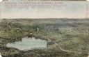
| Date: | 1910 |
|---|---|
| Description: | Photographic postcard of an elevated view looking across the downtown area. The Crawfish River is on the left. Caption reads: "Bird's-Eye View, Columbus, W... |

| Date: | 1974 |
|---|---|
| Description: | This map shows streets, Lake Winnebago, Little Lake Butte Des Morts, and the Fox River. Also included is text on the Fox River Waterways and the history of... |

| Date: | 1937 |
|---|---|
| Description: | Pictorial map showing historical events and locations within the state of Wisconsin, as well as waterways and counties. Original caption on the bottom marg... |

| Date: | 1630 |
|---|---|
| Description: | One of the few maps by Dutch cartographer Willem Blaeu depicting the Americas, this map shows regions, settlements, islands, mountains, forests, rivers, an... |

| Date: | 1719 |
|---|---|
| Description: | This extremely detailed and ornate map shows the cities, Native American land, mountains, lakes, rivers, and European claims of North America. An inset map... |

| Date: | 1874 |
|---|---|
| Description: | Birds-eye view of Appleton Wisconsin. In the foreground are people fishing, strolling, and looking over the canal towards the Fox River. Streets and buildi... |
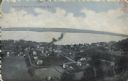
| Date: | 1908 |
|---|---|
| Description: | Illustrated postcard of Lake Winnebago and the surrounding communities. Text on front reads: "Looking northwest from the east shore of Lake Winnebago showi... |

| Date: | 1908 |
|---|---|
| Description: | Bird's-eye view showing Lake Mendota, Lake Monona, Lake Waubesa, Lake Wingra and Lake Kegonsa. Madison has only the isthmus developed, and there are settle... |

| Date: | 1928 |
|---|---|
| Description: | Birds-eye view showing Lake Mendota, Lake Monona, Lake Wingra, Lake Waubesa and Lake Kegonsa. Shows the growth of Madison from the Isthmus along the southe... |

| Date: | |
|---|---|
| Description: | Elevated view of the Red Cedar Dam and power plants. Caption reads: "Menomonie, Wis. Bird's Eye View, Water Power and Plants." |

| Date: | 1940 |
|---|---|
| Description: | Text on front reads: "Birdseye, Business Center, Richland Center, Wis." An aerial view, looking north, of the town situated between tree covered hills. The... |

| Date: | 1950 |
|---|---|
| Description: | Text on front reads: "Horseshoe Curve At Rock Springs, Wis." A road and a railroad track, with bridges over the Baraboo River, make a double curve in an el... |
| Date: | 05 19 1908 |
|---|---|
| Description: | Text on front reads: "Bird's-Eye View of Stockholm, Wis." A village in Pepin County, founded in 1854 by immigrants from Karlskoga, Sweden, who named it aft... |
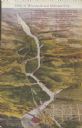
| Date: | 1910 |
|---|---|
| Description: | Text on front reads: "Dells of Wisconsin and Kilbourn City." An illustrated Bird's Eye View of the Dells area with 33 numbered features: "1 - High Rock, 2 ... |
If you didn't find the material you searched for, our Library Reference Staff can help.
Call our reference desk at 608-264-6535 or email us at: