 Filter: Categories of Wisconsin Historical Images
Filter: Subject of Bird's-eye views
Filter: Subject of mississippi river
Filter: Categories of Wisconsin Historical Images
Filter: Subject of Bird's-eye views
Filter: Subject of mississippi river

| Date: | 1870 |
|---|---|
| Description: | During the War of 1812, the only battle fought in Wisconsin was in Prairie du Chien, in 1814. Made fifty-six years later, this birds eye drawing depicts th... |

| Date: | 1880 |
|---|---|
| Description: | Alma was platted and settled in 1855, on a narrow strip of land between high bluffs and the Mississippi River. Its location made it a popular shipping cent... |

| Date: | 1867 |
|---|---|
| Description: | Bird's-eye map of La Crosse with nine insets of residences, schools, and the Court House and Jail. |

| Date: | 1873 |
|---|---|
| Description: | Bird's-eye map of La Crosse from the Mississippi River. |

| Date: | 1887 |
|---|---|
| Description: | Bird's-eye map of La Crosse, with six insets including residences, a store front, The John Gund Brewing Company, and C. & J. Michel Brewing Company. |

| Date: | 1880 |
|---|---|
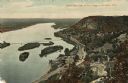
| Description: | Bird's-eye map over the Mississippi River of Fountain City. Paddle steamers and steamboats are on the river, and bluffs are in the background. |

| Date: | 1884 |
|---|---|
| Description: | Bird's-eye view drawing of the grounds of Villa Louis, the estate of the fur trading Dousman family. After the death of H. Louis Dousman's mother in 1882, ... |

| Date: | 1906 |
|---|---|
| Description: | Bird's-eye view of McGregor on the Mississippi River. |
| Date: | 1925 |
|---|---|
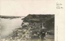
| Description: | Elevated view of Genoa. Caption reads: "Bird's Eye View, Genoa, Wis." The St. Charles Borromeo Catholic Church is in the right foreground. Railroad tracks ... |

| Date: | |
|---|---|
| Description: | Composite of sixteen views mainly views of types of boats on the Mississippi River, including steamboats and excursion boats; one view is a bird-eye view o... |

| Date: | |
|---|---|
| Description: | A bird's eye view overlooking the Mississippi River, sand bars, the railroad bridge, surrounding forests and wetlands. |
| Date: | 1910 |
|---|---|
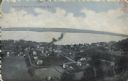
| Description: | Color enhanced aerial view of the village of DeSoto, looking north along the Mississippi River. Caption reads: "Bird's Eye View of the Village of De Soto, ... |

| Date: | 1937 |
|---|---|
| Description: | Pictorial map showing historical events and locations within the state of Wisconsin, as well as waterways and counties. Original caption on the bottom marg... |

| Date: | 1900 |
|---|---|
| Description: | This set of photocopy bird's-eye-view maps include one view looking west from the top of Wisconsin River bluffs; and a second view looking east towards La ... |

| Date: | 1719 |
|---|---|
| Description: | This extremely detailed and ornate map shows the cities, Native American land, mountains, lakes, rivers, and European claims of North America. An inset map... |
| Date: | 05 19 1908 |
|---|---|
| Description: | Text on front reads: "Bird's-Eye View of Stockholm, Wis." A village in Pepin County, founded in 1854 by immigrants from Karlskoga, Sweden, who named it aft... |
If you didn't find the material you searched for, our Library Reference Staff can help.
Call our reference desk at 608-264-6535 or email us at:
