 Filter: Categories of Wisconsin Historical Images
Filter: Subject of Bird's-eye views
Filter: Subject of factories
Filter: Categories of Wisconsin Historical Images
Filter: Subject of Bird's-eye views
Filter: Subject of factories

| Date: | 1886 |
|---|---|
| Description: | Bird's-eye view of Bayfield, county seat of Bayfield County. On the lower left side is an inset for Bayfield and the Apostle Islands. |

| Date: | 1853 |
|---|---|
| Description: | Bird's-eye map of Milwaukee looking east toward Lake Michigan from a bluff, long since graded into a slope, at about 6th Street between Wisconsin Avenue an... |
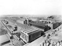
| Date: | 1910 |
|---|---|
| Description: | Birds-eye view of International Harvester's Milwaukee Works located at 1714 West Bruce Street. The factory was originally owned by the Milwaukee Harvester ... |

| Date: | 1867 |
|---|---|
| Description: | Birds-eye drawing of Appleton, Outagamie Co., depicting street names and street layout, houses, the Fox River, the court house, jail, school houses, Lawren... |

| Date: | 1867 |
|---|---|
| Description: | Birds-eye drawing of Beaver Dam, Dodge Co., depicting street names and street layout, houses, rivers, lakes, and trees. A reference key at the bottom of th... |

| Date: | 1890 |
|---|---|
| Description: | Bird's-eye map of Beloit with insets of Williams Engine Works, Eclipse Wind Engine Co., and John Foster & Co. Turtle Creek is in the lower section, and the... |

| Date: | 1867 |
|---|---|
| Description: | Birds eye drawing of Fond du Lac depicts street names and street layouts, houses, buildings, trees, and the Fond du Lac River. A reference key at the botto... |

| Date: | 1882 |
|---|---|
| Description: | Bird's-eye views of various sections of Milwaukee. |

| Date: | 1885 |
|---|---|
| Description: | Bird's-eye view of Sheboygan, with inset of J.J. Volrath Manufacturing Company. |

| Date: | 1913 |
|---|---|
| Description: | Bird's-eye map of Superior. "The New Steel Center." |

| Date: | 1885 |
|---|---|
| Description: | Bird's-eye map of Waupun on the Rock River. There is an inset at top center of "Althouse, Wheeler & Co., Windmills and Pumps." |

| Date: | 2007 |
|---|---|
| Description: | This map of Cedarbug is a bird's-eye map with 8 inset views and an index. The map is a print out of the original map dated 1892 held at the Cedarburg Cultu... |

| Date: | 1872 |
|---|---|
| Description: | Birds-eye drawing of Eau Claire depicts street names and street locations, houses, trees, bridges, piers, canals, railroads, and the Chippewa and Eau Clair... |

| Date: | 1891 |
|---|---|
| Description: | Bird's-eye view of Eau Claire. |

| Date: | 1893 |
|---|---|
| Description: | Bird's-eye map of Jefferson, looking north. Crayfish River at left and center, Rock River from upper center to bottom center, joins at left of center; thir... |

| Date: | 12 21 1882 |
|---|---|
| Description: | Bird's-eye map of Kaukauna, from the Appleton Post Annual Review. |

| Date: | 1870 |
|---|---|
| Description: | Bird's-eye view of the city of Manitowoc with a population of 5,168 inhabitants as it appears in 1870, the year the village was granted a city charter by t... |

| Date: | 1883 |
|---|---|
| Description: | Bird's-eye map of Marshfield, with one vignette. |
If you didn't find the material you searched for, our Library Reference Staff can help.
Call our reference desk at 608-264-6535 or email us at:

