 Filter: Categories of Wisconsin Historical Images
Filter: Subject of Bird's-eye views
Filter: Community of Superior
Filter: Categories of Wisconsin Historical Images
Filter: Subject of Bird's-eye views
Filter: Community of Superior

| Date: | 1883 |
|---|---|
| Description: | Bird's-eye map of Superior, county seat of Douglas County, on the shores of Lake Superior, with insets of points of interest. |

| Date: | 1890 |
|---|---|
| Description: | Bird's-eye view of Superior, Wisconsin. |

| Date: | 1913 |
|---|---|
| Description: | Bird's-eye map of Superior. "The New Steel Center." |

| Date: | 1915 |
|---|---|
| Description: | Bird's-eye view of Superior, Wisconsin, and Duluth, Minnesota on opposite shore of Lake Superior. |

| Date: | 1887 |
|---|---|
| Description: | Bird's-eye view of Superior, on Lake Superior. |

| Date: | 1890 |
|---|---|
| Description: | Bird's-eye map of West Superior and Superior, with insets of Wright Farm and First Building in Superior. |

| Date: | 1893 |
|---|---|
| Description: | Bird's-eye map of Superior. Looking from the point, with Superior Bay on left, St. Louis Bay on right, below St. Louis River. |
| Date: | 1907 |
|---|---|
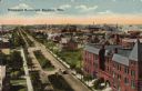
| Description: | Text on front reads: "Hammond Boulevard, Superior, Wis." A bird's-eye view of a tree and home lined boulevard in a neighborhood. A horse-drawn wagon is on ... |
If you didn't find the material you searched for, our Library Reference Staff can help.
Call our reference desk at 608-264-6535 or email us at: