 Filter: Categories of Wisconsin Historical Images
Filter: Subject of Bicycles
Filter: Year of 2000-Present
Filter: Categories of Wisconsin Historical Images
Filter: Subject of Bicycles
Filter: Year of 2000-Present
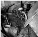
| Date: | 2003 |
|---|---|
| Description: | Barbed wire and bicycle in the barn on the Quinney farm. |
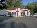
| Date: | 2008 |
|---|---|
| Description: | Built by Clayton "Clayt" Parman in 1941, the service station at 3502 Monroe Street looks almost identical to when it opened more than sixty-five years ago. |
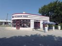
| Date: | 2008 |
|---|---|
| Description: | In 2001 the former Copeland Service Station reopened as a coffee shop in Milwaukee's Sherman Park neighborhood. The restored building is located at 4924 We... |
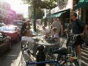
| Date: | 2009 |
|---|---|
| Description: | Customers around outside seating at Jule's Coffee shop on Pearl Street. |
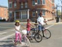
| Date: | 2006 |
|---|---|
| Description: | Father and two children stopped at an intersection while on a bike ride. |
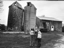
| Date: | 2004 |
|---|---|
| Description: | Cherie Krenz Schellinger and her children, Dawn and David, live at 7464 Freedom Road (Section 35). Note the very old wooden silo. |
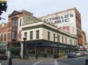
| Date: | 2007 |
|---|---|
| Description: | An exterior view from across street of Bodega Brew Pub on corner of Pearl Street. |
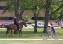
| Date: | 2008 |
|---|---|
| Description: | A female bike rider looks over at police officer riding a horse at Riverside Park. |
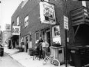
| Date: | 07 25 2008 |
|---|---|
| Description: | "NJ's South Main Pub is located at 122 South Milwaukee Street, Theresa. Our guest today is Richard Yehl." |

| Date: | 2012 |
|---|---|
| Description: | Paper boy riding a bike along Charles Street on Labor Day. He is wearing a green shirt, camouflage shorts and white tennis shoes. In the background is a ne... |

| Date: | 2008 |
|---|---|
| Description: | This double sided map shows roads, railroads, biking trails, civil townships, parks, wildlife refuges, town halls, and hospitals. The region map covers par... |
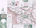
| Date: | 2001 |
|---|---|
| Description: | This map shows county boundaries, cities, roads, and bikes trails in the west-central region in Wisconsin. Portions of Minnesota and Iowa are visible. Inc... |

| Date: | 10 2013 |
|---|---|
| Description: | Low angle view of two people (faces out of frame) sitting on stools at a small square table next to a window at a cafe. Outside the window a man is riding ... |
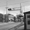
| Date: | 11 2013 |
|---|---|
| Description: | View from sidewalk down Lakeside Street towards a railroad crossing. Across the street beyond the railroad tracks are four buildings with cars parked in fr... |

| Date: | 2004 |
|---|---|
| Description: | This map shows ATMs, houses of worship, hotels, parking ramps, public parking, union cab stands, bus stops, business district, parks and public areas, gove... |

| Date: | 2005 |
|---|---|
| Description: | This map shows dams and falls, areas of portage, canoe and kayak access, boat launches, parking, restrooms, picnic areas, dining, rapid water, parks, and b... |
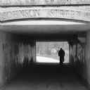
| Date: | 05 2014 |
|---|---|
| Description: | Silhouette of a person riding a bicycle through a pedestrian tunnel under East Johnson Street near the Yahara River and Tenney Park. Above the entrance to ... |

| Date: | 06 2014 |
|---|---|
| Description: | View of a large sign in the Arboretum posted at the side of a road depicting a frog on a branch to mark the crossing of frogs between wetland and lake. In ... |
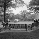
| Date: | 06 2014 |
|---|---|
| Description: | View of a woman sitting on one of three benches at the Sunset Point Overlook in Hoyt Park. In the background three cars are parked facing the stone wall of... |

| Date: | 07 2014 |
|---|---|
| Description: | View from the top of Monona Terrace looking down towards the large arched windows. There are plants and trees in the concrete planters that are part of the... |
If you didn't find the material you searched for, our Library Reference Staff can help.
Call our reference desk at 608-264-6535 or email us at: