 Filter: Categories of Wisconsin Historical Images
Filter: Subject of Bicycles
Filter: Year of 2000-Present
Filter: Type of Map or Atlas
Filter: Categories of Wisconsin Historical Images
Filter: Subject of Bicycles
Filter: Year of 2000-Present
Filter: Type of Map or Atlas

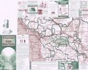
| Date: | 2008 |
|---|---|
| Description: | This double sided map shows roads, railroads, biking trails, civil townships, parks, wildlife refuges, town halls, and hospitals. The region map covers par... |
| Date: | 2001 |
|---|---|
| Description: | This map shows county boundaries, cities, roads, and bikes trails in the west-central region in Wisconsin. Portions of Minnesota and Iowa are visible. Inc... |

| Date: | 2004 |
|---|---|
| Description: | This map shows ATMs, houses of worship, hotels, parking ramps, public parking, union cab stands, bus stops, business district, parks and public areas, gove... |

| Date: | 2005 |
|---|---|
| Description: | This map shows dams and falls, areas of portage, canoe and kayak access, boat launches, parking, restrooms, picnic areas, dining, rapid water, parks, and b... |
If you didn't find the material you searched for, our Library Reference Staff can help.
Call our reference desk at 608-264-6535 or email us at: