 Filter: Categories of Wisconsin Historical Images
Filter: Subject of Bicycles
Filter: Subject of cities and towns
Filter: Subject of water
Filter: Categories of Wisconsin Historical Images
Filter: Subject of Bicycles
Filter: Subject of cities and towns
Filter: Subject of water
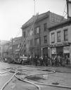
| Date: | 03 20 1935 |
|---|---|
| Description: | View across street towards the Madison Steam Laundry, at 433 State Street, the scene of a fire. In front of the building is a fire truck with extension lad... |
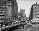
| Date: | 07 11 1912 |
|---|---|
| Description: | Looking east on E. Wisconsin Avenue from the west bank of the Milwaukee River. The Pabst Building is on the left. |

| Date: | 1896 |
|---|---|
| Description: | View of Silver Spring and the surrounding countryside. In the background, there is a man on a bicycle, two individuals in a horse-drawn vehicle and a small... |
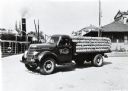
| Date: | 03 1938 |
|---|---|
| Description: | An International Model D-30 truck loaded with twine is parked near a body of water in Uppsala, Sweden. A large ship is in the background. The truck was own... |
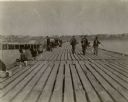
| Date: | 1900 |
|---|---|
| Description: | Long wooden pier with people fishing along the pier. Three males with their fishing poles and buckets are walking toward the viewer. A person next to a b... |
| Date: | |
|---|---|
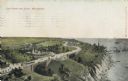
| Description: | Elevated view with the lake on the right, with a number of boats near the shoreline. There is a long winding road through the park, including bridges, a fo... |
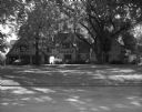
| Date: | 08 28 1966 |
|---|---|
| Description: | Exterior view of a large, Tudor style mansion on the shores of Lake Winnebago. |

| Date: | 1896 |
|---|---|
| Description: | Section 2 of 12, this bicycle road map features Wisconsin bicycle routes in the counties of Marquette, Green Lake, Columbia, Fond Du Lac, Dodge, Washington... |
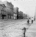
| Date: | 1900 |
|---|---|
| Description: | Syl stands holding an umbrella near an unidentified boy who is leaning on a bicycle on the edge of a cobblestone street. Storefronts are along the street o... |
| Date: | 06 12 1899 |
|---|---|
| Description: | Elevated view over water, perhaps Hatfield Lake, of damage to houses and property caused by a tornado. Groups of people are scattered throughout the town. |
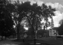
| Date: | |
|---|---|
| Description: | View of the central city park and its fountain with the First Congregational Church in the background. |
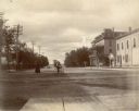
| Date: | 1910 |
|---|---|
| Description: | A woman crosses Monona Avenue as a man on a bicycle rides by. The large, Second Empire style Avenue Hotel, with two-story porch, is on the left; the GAR ha... |
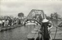
| Date: | 1968 |
|---|---|
| Description: | Pedestrians file single file across the make-shift repairs to the bridge over the Perfume River at Hue. The bridge was bombed by the Vietcong during the Te... |

| Date: | 1994 |
|---|---|
| Description: | This brochure consists of a series of 16 maps of the Military Ridge State Park Trail and the Sugar River State Trail. In all, 62 miles of bike trails and 1... |

| Date: | 1987 |
|---|---|
| Description: | This 1987 map of Racine and Kenosha counties, Wisconsin, shows towns, sections, cities and villages, zip code boundaries, highways and roads, bicycle route... |

| Date: | 1990 |
|---|---|
| Description: | Map of bike routes in Madison. Lower right corner features a system map with legend. Upper left corner is an inset of the Capital Loop with labelled points... |
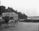
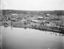
| Date: | 1922 |
|---|---|
| Description: | Elevated view across water of a stone building next to an earthen dam on the La Crosse River. There is an archway on the side of the building at the river ... |

| Date: | |
|---|---|
| Description: | The bargain was that the driven wedge would never be withdrawn |

| Date: | |
|---|---|
| Description: | View across lawn and the Yahara River towards the Hausmann Brewing Company's Malt House in the center background. On the right is the Yahara River bridge. ... |

| Date: | 2004 |
|---|---|
| Description: | This map shows ATMs, houses of worship, hotels, parking ramps, public parking, union cab stands, bus stops, business district, parks and public areas, gove... |
If you didn't find the material you searched for, our Library Reference Staff can help.
Call our reference desk at 608-264-6535 or email us at: