 Filter: Categories of Wisconsin Historical Images
Filter: Subject of Bicycles
Filter: Type of Map or Atlas
Filter: Subject of roads
Filter: Categories of Wisconsin Historical Images
Filter: Subject of Bicycles
Filter: Type of Map or Atlas
Filter: Subject of roads
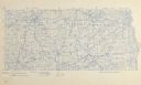
| Date: | 1896 |
|---|---|
| Description: | Section 1 of 12, this bicycle road map features Wisconsin bicycle routes in the counties of Dane, Jefferson, Waukesha, Milwaukee, Green, Rock, Walworth, Ra... |

| Date: | 1896 |
|---|---|
| Description: | Section 2 of 12, this bicycle road map features Wisconsin bicycle routes in the counties of Marquette, Green Lake, Columbia, Fond Du Lac, Dodge, Washington... |

| Date: | 1896 |
|---|---|
| Description: | Section 12 of 12, this bicycle road map features Wisconsin bicycle routes in the counties of Douglas, Bayfield, Burnett, Washburn, Sawyer, Price, Ashland, ... |

| Date: | 1994 |
|---|---|
| Description: | This brochure consists of a series of 16 maps of the Elroy-Sparta State Trail and the 400 State Trail, as well as the Omaha Trail between Sparta and Camp D... |

| Date: | 1994 |
|---|---|
| Description: | This brochure presents a series of 16 maps of the Glacial Drumlin Trail and the New Berlin Trail. The Glacial Drumlin Trail consists of 53 miles of bike tr... |

| Date: | 1994 |
|---|---|
| Description: | This brochure consists of a series of 16 maps of the Military Ridge State Park Trail and the Sugar River State Trail. In all, 62 miles of bike trails and 1... |

| Date: | 1987 |
|---|---|
| Description: | This 1987 map of Racine and Kenosha counties, Wisconsin, shows towns, sections, cities and villages, zip code boundaries, highways and roads, bicycle route... |

| Date: | 1992 |
|---|---|
| Description: | This guide features a map of suggested bike routes. Also included is a legend, text on how to use the map and legend, points of interest, and safety tips. |

| Date: | 2008 |
|---|---|
| Description: | This double sided map shows roads, railroads, biking trails, civil townships, parks, wildlife refuges, town halls, and hospitals. The region map covers par... |
If you didn't find the material you searched for, our Library Reference Staff can help.
Call our reference desk at 608-264-6535 or email us at: