 Filter: Categories of Wisconsin Historical Images
Filter: Subject of Bears
Filter: Subject of men
Filter: Subject of political science
Filter: Categories of Wisconsin Historical Images
Filter: Subject of Bears
Filter: Subject of men
Filter: Subject of political science
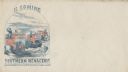
| Date: | 1860 |
|---|---|
| Description: | A circus traveling on the road has three cages, the first and second are flying the Confederate flag. A stone at the side of the road says "TO BOSTON." "T... |

| Date: | 1978 |
|---|---|
| Description: | Wisconsin Congressman David R. Obey with pre-schoolers and their teacher at Ellis School, a program supported in part by Title I federal funding. Throughou... |

| Date: | 1758 |
|---|---|
| Description: | This map of the north-west hemisphere shows the cities, lakes, rivers, mountains, and political borders. In the upper left corner sits a decorative cartouc... |

| Date: | 1766 |
|---|---|
| Description: | This map of North America shows the boundaries of European claims at the end of the French and Indian war. The British colonies extend to the Mississippi. ... |
If you didn't find the material you searched for, our Library Reference Staff can help.
Call our reference desk at 608-264-6535 or email us at: