 Filter: Categories of Wisconsin Historical Images
Filter: Subject of Bays
Filter: Year of 1900-1999
Filter: Year of 1940-1949
Filter: Categories of Wisconsin Historical Images
Filter: Subject of Bays
Filter: Year of 1900-1999
Filter: Year of 1940-1949
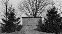
| Date: | 1944 |
|---|---|
| Description: | View of the Radisson and Groseilliers marker at the site of the first house built by white men in Wisconsin. The marker is located in the vicinity of Ashla... |
| Date: | 1940 |
|---|---|
| Description: | Memorial to the Moravians who arrived in Eagle Bay in 1853. |

| Date: | 1944 |
|---|---|
| Description: | Shows roads, railroads, schools, dairy plants, seaplane bases, wayside parks, and commercial/municipal fields. "Marathon Forms Map Service, Wisconsin repre... |

| Date: | 1948 |
|---|---|
| Description: | This 1948 map shows contour and spot depths in Lake Wingra in Madison, Wisconsin. The shore outline is based on a 1940 aerial photograph. |

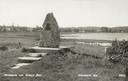
| Date: | 1943 |
|---|---|
| Description: | This map of Sturgeon Bay shows section and quarter corners, ward divisions, government building locations, roads, and railroads. The map includes a legend ... |

| Date: | 1941 |
|---|---|
| Description: | Elevated view of Sturgeon Bay in 1900. Sturgeon Bay Bridge spans the bay and several boats are on the water. A lighthouse sits on a small island in the bay... |
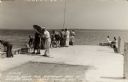
| Date: | 1940 |
|---|---|
| Description: | Photographic postcard view looking out at people standing, and some fishing, on the Northport pier at Death's Door, with the bay in the background. |

| Date: | 04 11 1940 |
|---|---|
| Description: | This blue line print map shows survey monument markers by type and industrial buildings and covers part of the lower Fox River and East River. The map incl... |
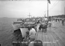
| Date: | 1940 |
|---|---|
| Description: | View of a crowd gathered along a pier for Regatta Day. Boats are docked alongside the pier on the left. |

| Date: | 1944 |
|---|---|
| Description: | Elevated view of Fish Creek and Green Bay. Dwellings are in the foreground. The Peninsula State Park is across the bay. Caption reads: "Fish Creek, Wis. Fr... |
| Date: | 1941 |
|---|---|
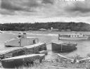
| Description: | Three boats, including the Sea Skipper, are tied to a wooden pier near the beach at Sister Bay. Another craft, the Flussheim of Sister Bay, i... |

| Date: | 1940 |
|---|---|
| Description: | A woman wearing a bandana on her head is sitting at a picnic table talking with another woman who is standing in front of a tent-style camping trailer. Bot... |

| Date: | 1940 |
|---|---|
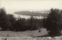
| Description: | A split rail fence in the foreground frames a view of Eagle Harbor and Ephraim from Peninsula State Park. |
| Date: | 07 29 1946 |
|---|---|
| Description: | Text on front reads: "Little Sister and Sister Bays, Sister Bay, Wis." A view from a hill of the shoreline of Green Bay, Lake Michigan. |
| Date: | 1940 |
|---|---|
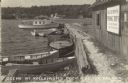
| Description: | Text on front reads: "Scene at Kellstrom's Dock, Sister Bay, Wis." View of Sister Bay from a boathouse and dock, the sign reads: "Kellstrom's Fishing Trips... |
| Date: | 1940 |
|---|---|
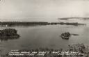
| Description: | Text on front reads: "Sawyer Harbor and Cabot's Point from Tower, Potowatomi State Park, Door County, Wis." Elevated view across Sawyer Harbor towards Stur... |
If you didn't find the material you searched for, our Library Reference Staff can help.
Call our reference desk at 608-264-6535 or email us at: