 Filter: Categories of Wisconsin Historical Images
Filter: Subject of Bays
Filter: Year of 1900-1999
Filter: Year of 1920-1929
Filter: Categories of Wisconsin Historical Images
Filter: Subject of Bays
Filter: Year of 1900-1999
Filter: Year of 1920-1929

| Date: | 1929 |
|---|---|
| Description: | View of an ore dock on Chequamegon Bay. Buildings on the shore of the bay can be seen, however, not the water. |

| Date: | 1920 |
|---|---|
| Description: | Caption reads: "Mammoth Ore Docks, Ashland, Wis." A building and roads are in the foreground. Several ore ships can be seen. |

| Date: | 1929 |
|---|---|
| Description: | Ferryboat landing, with the boats providing service between Gills Rock and Washington Island. |

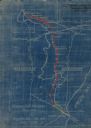
| Date: | 1924 |
|---|---|
| Description: | Plat map showing a portion of Liberty Grove, T32-33N R29E. The land is bordered on the south by Rowley's Bay, on the east by Lake Michigan and Europe Bay, ... |

| Date: | 1924 |
|---|---|
| Description: | This map is pen, pencil, and watercolor on paper and shows land ownership by name, local streets, railroads, and part of Chequamegon Bay. The map includes ... |

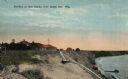
| Date: | 1920 |
|---|---|
| Description: | View from beach across Spike Horn Bay towards Cana Island and the Cana Island Light. |

| Date: | 06 1923 |
|---|---|
| Description: | Sanborn map of Ashland, which includes Chequamegon Bay. |

| Date: | 1924 |
|---|---|
| Description: | This map shows streets, selected buildings, railroads, railway yards, schools, parks, schools, cemeteries, bays, the Milwaukee River, and Lake Michigan. De... |

| Date: | 1925 |
|---|---|
| Description: | This map shows lakes, islands and bays. The Upper Peninsula of Michigan and Ontario are labeled. Three inset maps include the Upper end of St. Marys River ... |

| Date: | 04 1926 |
|---|---|
| Description: | This blueprint mostly shows various numbers within the canal and bay. Lake Michigan and Harobor of Refuge are shown along the far right side. Near the harb... |
| Date: | 1923 |
|---|---|
| Description: | This blueprint map shows Wisconsin and Michigan-owned railroad and trackage rights from Iron Mountain to Menominee, Michigan, as well as other railroads. W... |

| Date: | 1920 |
|---|---|
| Description: | This blue line print map shows land claimed by the state and land claimed by Michigan, including disputed areas between the Branch River and Brule Lake and... |

| Date: | 1920 |
|---|---|
| Description: | This map represents around 1841 and shows Lake Superior, other lakes, rivers, bays, and the border between Michigan and Wisconsin. There are annotations in... |

| Date: | 1928 |
|---|---|
| Description: | This map shows roads, cities, lakes, rivers, points of interest and county boundaries. Through routes are outlined in red. Includes an index to cities and ... |

| Date: | 1927 |
|---|---|
| Description: | This map details automobile routes throughout the state as well as parts of Iowa, Minnesota, Michigan and Illinois. Cities, the Mississippi River, Lake Mic... |

| Date: | 1920 |
|---|---|
| Description: | This map details automobile routes spanning across Wisconsin and parts of Illinois, Michigan, Minnesota, and Iowa. Cities, counties, Lake Michigan, Lake Su... |

| Date: | 1924 |
|---|---|
| Description: | This map shows automobile routes across the state and into parts of Minnesota, Iowa, Illinois, and Michigan. Cities, Lake Michigan, Lake Superior, Green Ba... |
| Date: | 1926 |
|---|---|
| Description: | Colorized postcard of a beachside pavilion and the long, wooden staircase leading down to the waterfront. Caption reads: "Pavilion at Red Banks, near Green... |

| Date: | 1923 |
|---|---|
| Description: | Color map of the "Interborough Rapid Transit System of Greater New York". |
If you didn't find the material you searched for, our Library Reference Staff can help.
Call our reference desk at 608-264-6535 or email us at:
