 Filter: Categories of Wisconsin Historical Images
Filter: Subject of Bays
Filter: Subject of transportation
Filter: Categories of Wisconsin Historical Images
Filter: Subject of Bays
Filter: Subject of transportation

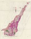
| Date: | 1930 |
|---|---|
| Description: | Original map made with watercolor and inkwash. Includes a legend of buildings, roads, natural features and other details of the lodge. Inset at bottom has ... |

| Date: | 1905 |
|---|---|
| Description: | This map shows railroads, towns, lights, lights to be established, fog signals, light-vessels, lighted buoys, light-house depots, and light-house reservati... |

| Date: | 1905 |
|---|---|
| Description: | This map shows railroads, towns, lights, lights to be established, fog signals, light-vessels, lighted buoys, light-house depots, and light-house reservati... |

| Date: | 1925 |
|---|---|
| Description: | This map shows lakes, islands and bays. The Upper Peninsula of Michigan and Ontario are labeled. Three inset maps include the Upper end of St. Marys River ... |

| Date: | 1906 |
|---|---|
| Description: | This map shows railroads, rivers, bays, channels, shoreline and hydrography around Thunder Bay, Ontario. Depths are shown by soundings, isolines, and tints... |

| Date: | 1900 |
|---|---|
| Description: | This photostat map was probably originally created in 1835 and shows in addition to private claims, mills, roads, and trails. Green Bay and the Fox River a... |

| Date: | 1906 |
|---|---|
| Description: | This map shows bays, creeks, railroads and rivers. Relief is shown by contours and spot heights. Depths are shown by contours, tints, and soundings. Includ... |
| Date: | 1961 |
|---|---|
| Description: | This map shows bays, lakes, and roads. Relief is shown by contours; depths are shown by isolines. Lake Michigan and Lake Winnebago are labeled. An explana... |

| Date: | 1918 |
|---|---|
| Description: | Manuscript map of the Chequamegon Bay area on Lake Superior drawn by Warren W. Witmer and illustrated with sketches by Mary L. Wright Witmer in ink and wat... |

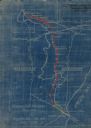
| Date: | 04 11 1940 |
|---|---|
| Description: | This blue line print map shows survey monument markers by type and industrial buildings and covers part of the lower Fox River and East River. The map incl... |

| Date: | 1990 |
|---|---|
| Description: | This map shows the Minnesota Point, Wisconsin Point, Hog Island, Baker's Island, Connors Point, Blatnik Bridge, Superior Bay, Allouez Bay, the Nemadji Rive... |

| Date: | 04 1926 |
|---|---|
| Description: | This blueprint mostly shows various numbers within the canal and bay. Lake Michigan and Harobor of Refuge are shown along the far right side. Near the harb... |

| Date: | 1900 |
|---|---|
| Description: | This map shows AS&IR Railroad between Siskiwit and Nash (with dock), a proposed extension of AS&IR Railroad "now under construction" between Superior and N... |

| Date: | 1855 |
|---|---|
| Description: | This map shows current and purposed railroad routes. Lake Michigan is on the far right, with Lake Superior visible at the top of the map. Routes are marked... |

| Date: | 1960 |
|---|---|
| Description: | This map shows public boat ramps, parks, highways, beaches, bluffs, Green Bay, Garrett Bay, Europe Bay and Lake, Rowley's Bay and Ellison Bay. The map incl... |

| Date: | 1831 |
|---|---|
| Description: | This map shows the land that makes up Michigan, Wisconsin, Minnesota, Indiana, and parts of Canada. The Great Lakes are displayed prominently, along with s... |
| Date: | 1923 |
|---|---|
| Description: | This blueprint map shows Wisconsin and Michigan-owned railroad and trackage rights from Iron Mountain to Menominee, Michigan, as well as other railroads. W... |
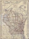
| Date: | 1933 |
|---|---|
| Description: | This map shows cities, rivers, lakes, roads, county boundaries, and destinations. Scenic and historic trails are shown in red. The map includes indexes to ... |

| Date: | 1920 |
|---|---|
| Description: | This blue line print map shows land claimed by the state and land claimed by Michigan, including disputed areas between the Branch River and Brule Lake and... |
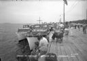
| Date: | 1940 |
|---|---|
| Description: | View of a crowd gathered along a pier for Regatta Day. Boats are docked alongside the pier on the left. |
If you didn't find the material you searched for, our Library Reference Staff can help.
Call our reference desk at 608-264-6535 or email us at: