Filter: Categories of Wisconsin Historical Images
Filter: Subject of Bays
Filter: Subject of transportation
Filter: County of Brown
Filter: Categories of Wisconsin Historical Images
Filter: Subject of Bays
Filter: Subject of transportation
Filter: County of Brown
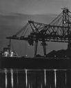
| Date: | 1914 |
|---|---|
| Description: | View of docks with ships tied up for the winter. The Reiss coal yard is in the background. |
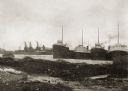
| Date: | 1910 |
|---|---|
| Description: | Walkway on the bluff leading down to a pavilion on the shoreline. Houses are in the background. Caption reads: "Pavilion at Bendersville, near Green Bay, W... |

| Date: | 1974 |
|---|---|
| Description: | This map shows roads, highways, railroads, major arterials, towns, parks, recreational areas, and parts of Fox River and bay of Green Bay. The map includes... |

| Date: | 1930 |
|---|---|
| Description: | This map shows a plat of the town, local streets, railroads, creeks, part of Fox River, and part of the bay of Green Bay. The location of the original fort... |

| Date: | 1987 |
|---|---|
| Description: | This map pictorially shows local roads, local businesses with phone numbers, and parts of Fox River and bay of Green Bay. |

| Date: | 1914 |
|---|---|
| Description: | This map has relief shown by hachures and shows local streets, wards, districts, railroads, Fox River, and part of Bay of Green Bay. Wards are shown in dar... |
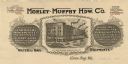
| Date: | |
|---|---|
| Description: | Letterhead of the Morley-Murphy Hardware Company, with a three-quarter view of the company building and horse, streetcar, and rail traffic around it. |

| Date: | 1874 |
|---|---|
| Description: | This map shows streets, buildings, railroads, the Fox River, the East River, and part of Green Bay. |

| Date: | 1963 |
|---|---|
| Description: | This blue line print shows as of March 1960 federal, state, county, and town roads, as well as railroads, schools, churches, town hall, parks, and Brown Co... |

| Date: | 1906 |
|---|---|
| Description: | This map shows streets, railroads, land use, public buildings, commercial businesses, and the Menominee River. Depths are shown by gradient tints and sound... |

| Date: | 1900 |
|---|---|
| Description: | This photostat map was probably originally created in 1835 and shows in addition to private claims, mills, roads, and trails. Green Bay and the Fox River a... |

| Date: | 04 11 1940 |
|---|---|
| Description: | This blue line print map shows survey monument markers by type and industrial buildings and covers part of the lower Fox River and East River. The map incl... |
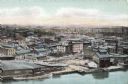
| Date: | |
|---|---|
| Description: | Aerial view of Green Bay from the bay. Commercial and industrial buildings are in the foreground. Waterfront businesses include F. Hurlbut Cement and W.W. ... |
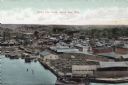
| Date: | |
|---|---|
| Description: | Bird's-eye view of Green Bay from the waterfront, with commercial buildings and factories. Caption reads: "Bird's Eye View, Green Bay, Wis." |
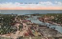
| Date: | |
|---|---|
| Description: | Aerial view of Green Bay, and the Fox River headed toward the bay. Commercial and industrial buildings are on the right bank, and residential neighborhoods... |

| Date: | |
|---|---|
| Description: | Hand-colored postcard elevated view of buildings along the Fox River. Boats moored in the foreground. A train is passing by across the river. Old Fort Howa... |

| Date: | 1901 |
|---|---|
| Description: | View across water towards the Steamer "Harriet A. Hart," with many passengers on board, and smoke coming out of the smokestack. Caption reads: "Steamer Har... |

| Date: | 1851 |
|---|---|
| Description: | Elevated view across water towards Fort Howard. In the foreground is a man standing on a pier, and in the water nearby are five men rowing in a boat. Capti... |
If you didn't find the material you searched for, our Library Reference Staff can help.
Call our reference desk at 608-264-6535 or email us at: