 Filter: Categories of Wisconsin Historical Images
Filter: Subject of Bays
Filter: Subject of service industries
Filter: Categories of Wisconsin Historical Images
Filter: Subject of Bays
Filter: Subject of service industries

| Date: | 1898 |
|---|---|
| Description: | Old Mission Residence at La Pointe, Madeline Island. |

| Date: | |
|---|---|
| Description: | The Old Mission Inn, originally built as a mission house in 1832 by the Congregational mission established by Frederick Ayer in 1830. In later years furthe... |
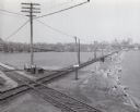
| Date: | 1955 |
|---|---|
| Description: | Elevated view of the Milwaukee Road and Chicago & Northwestern Railway crossing on Monona Bay, the site of the old MX tower. |

| Date: | 1954 |
|---|---|
| Description: | View looking west from Eagle Bluff toward Nicolet Bay, the Strawberry Islands, and Chambers Island. Three people are sitting on the stone wall of the overl... |

| Date: | 1957 |
|---|---|
| Description: | Large Letter style postcard for Green Bay depicting various scenes in the letters that spell the name of the city. Caption reads: "Greetings from Green Bay... |

| Date: | 1856 |
|---|---|
| Description: | A hand-colored map of Wisconsin, showing the county boundaries, towns, cities, railroads, roads, lakes, rivers, bays, and the Lake Superior’s islands. In ... |

| Date: | 1944 |
|---|---|
| Description: | Shows roads, railroads, schools, dairy plants, seaplane bases, wayside parks, and commercial/municipal fields. "Marathon Forms Map Service, Wisconsin repre... |

| Date: | 1932 |
|---|---|
| Description: | This map of Superior shows many points of interests including camping, fair grounds, docks, tourist attractions, lakes, roads, and waterways. |

| Date: | 1974 |
|---|---|
| Description: | This map shows roads, highways, railroads, major arterials, towns, parks, recreational areas, and parts of Fox River and bay of Green Bay. The map includes... |

| Date: | 1987 |
|---|---|
| Description: | This map pictorially shows local roads, local businesses with phone numbers, and parts of Fox River and bay of Green Bay. |

| Date: | |
|---|---|
| Description: | Exterior of the menu for Paul's Cafe, with a bird's-eye view map of "Washburn's Natural Deep Water Land Locked Harbor," Chequamegon Bay, and the Apostle Is... |

| Date: | 1894 |
|---|---|
| Description: | This map shows lot and block numbers, railroads, street car tracks, sewers, water mains, gas mains, paved streets, land owned by the Land & River Improveme... |

| Date: | 1966 |
|---|---|
| Description: | A colored map depiction of Door County, Wisconsin, with pictorial highlights, titled: "Door County — Wisconsin's Air Conditioned Peninsula Playground." |
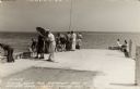
| Date: | 1940 |
|---|---|
| Description: | Photographic postcard view looking out at people standing, and some fishing, on the Northport pier at Death's Door, with the bay in the background. |

| Date: | 1930 |
|---|---|
| Description: | Original map made with watercolor and inkwash. Includes a legend of buildings, roads, natural features and other details of the lodge. Inset at bottom has ... |

| Date: | 1990 |
|---|---|
| Description: | This map shows the Minnesota Point, Wisconsin Point, Hog Island, Baker's Island, Connors Point, Blatnik Bridge, Superior Bay, Allouez Bay, the Nemadji Rive... |

| Date: | 1960 |
|---|---|
| Description: | This map shows public boat ramps, parks, highways, beaches, bluffs, Green Bay, Garrett Bay, Europe Bay and Lake, Rowley's Bay and Ellison Bay. The map incl... |

| Date: | 1927 |
|---|---|
| Description: | This map details automobile routes throughout the state as well as parts of Iowa, Minnesota, Michigan and Illinois. Cities, the Mississippi River, Lake Mic... |
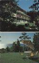
| Date: | |
|---|---|
| Description: | Two views of Egg Harbor Lodge — with the view of the lodge, and of Green Bay. |
If you didn't find the material you searched for, our Library Reference Staff can help.
Call our reference desk at 608-264-6535 or email us at:
