 Filter: Categories of Wisconsin Historical Images
Filter: Subject of Bays
Filter: Subject of intellectual life
Filter: Categories of Wisconsin Historical Images
Filter: Subject of Bays
Filter: Subject of intellectual life

| Date: | 1893 |
|---|---|
| Description: | Bird's-eye map of Sturgeon Bay, looking Northeast. Area bordered by Church Street in top left corner, leather & Smith Bridge in bottom left corner, Lawrenc... |

| Date: | 1880 |
|---|---|
| Description: | Bird's-eye map of Sturgeon Bay. County Seat of Door County. |

| Date: | 1950 |
|---|---|
| Description: | Aerial view of the confluence of the Fox River and Green Bay. |

| Date: | 1961 |
|---|---|
| Description: | Aerial view of the Duluth-Superior bridge. |

| Date: | 1917 |
|---|---|
| Description: | A geological survey map that map of southeastern Wisconsin shows the surface deposits east of the Wisconsin River, from the Illinois state line north to Ne... |

| Date: | |
|---|---|
| Description: | Exterior of the menu for Paul's Cafe, with a bird's-eye view map of "Washburn's Natural Deep Water Land Locked Harbor," Chequamegon Bay, and the Apostle Is... |
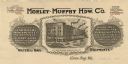
| Date: | |
|---|---|
| Description: | Letterhead of the Morley-Murphy Hardware Company, with a three-quarter view of the company building and horse, streetcar, and rail traffic around it. |

| Date: | 1935 |
|---|---|
| Description: | This map shows streets, railroads, and city wards. Streets, the Oconto River, and the Green Bay are labeled. The bottom of the map reads: "Compliments of O... |

| Date: | 1966 |
|---|---|
| Description: | A colored map depiction of Door County, Wisconsin, with pictorial highlights, titled: "Door County — Wisconsin's Air Conditioned Peninsula Playground." |

| Date: | |
|---|---|
| Description: | Aerial view of harbors and bridge. Farm fields are on either side of the bridge. The city of Sturgeon Bay is in the distance. There are docks along the sho... |

| Date: | 1930 |
|---|---|
| Description: | Original map made with watercolor and inkwash. Includes a legend of buildings, roads, natural features and other details of the lodge. Inset at bottom has ... |

| Date: | 1914 |
|---|---|
| Description: | This map shows township grids, railroads, roads, and drainage. The area of the map covers northeastern Wisconsin and Menominee Indian reservation. Green Ba... |

| Date: | 01 01 1959 |
|---|---|
| Description: | This map shows many of the rivers, dams, bays, harbors, lakes, and canals. It includes an index of authorized federal project, both for navigation and floo... |

| Date: | 1900 |
|---|---|
| Description: | This photocopy plat map of a paper city on the southeastern shore of Green Bay, probably in Brown County. The front includes a registration and the back in... |

| Date: | 1917 |
|---|---|
| Description: | This road map shows routes through the state as well as some portions of Iowa, Minnesota, and Michigan. Cities, the Mississippi River, Lake Winnebago, Gree... |

| Date: | 1927 |
|---|---|
| Description: | This map details automobile routes throughout the state as well as parts of Iowa, Minnesota, Michigan and Illinois. Cities, the Mississippi River, Lake Mic... |

| Date: | 1910 |
|---|---|
| Description: | This map shows automobile routes across the state as well as Minnesota, Iowa, Illinois, and Michigan. Cities, Lake Michigan, Lake Superior, the Mississippi... |

| Date: | 1915 |
|---|---|
| Description: | This map includes automobile routes through the state as well as routes in parts of Iowa, Michigan and Minnesota. Cities, counties, Lake Michigan, Lake Sup... |

| Date: | 1920 |
|---|---|
| Description: | This map details automobile routes spanning across Wisconsin and parts of Illinois, Michigan, Minnesota, and Iowa. Cities, counties, Lake Michigan, Lake Su... |

| Date: | 1894 |
|---|---|
| Description: | This map shows automobile routes across the state and into parts of Illinois, Michigan, Minnesota, and Iowa. Cities, counties, Lake Michigan, Lake Superior... |
If you didn't find the material you searched for, our Library Reference Staff can help.
Call our reference desk at 608-264-6535 or email us at: