 Filter: Categories of Wisconsin Historical Images
Filter: Subject of Bays
Filter: Subject of human settlements
Filter: Categories of Wisconsin Historical Images
Filter: Subject of Bays
Filter: Subject of human settlements

| Date: | 1929 |
|---|---|
| Description: | Ferryboat landing, with the boats providing service between Gills Rock and Washington Island. |

| Date: | 1950 |
|---|---|
| Description: | Aerial view of the confluence of the Fox River and Green Bay. |
| Date: | 1914 |
|---|---|
| Description: | View of docks with ships tied up for the winter. The Reiss coal yard is in the background. |

| Date: | 1905 |
|---|---|
| Description: | Indian cemetery. A large body of water is in the background. Caption reads: "Indian Burying Grounds, Bayfield, Wis." |
| Date: | 1905 |
|---|---|
| Description: | View across water towards Old Mission, as seen from the pier with Old Mission Congregational Church behind it. This Mission was established in 1830 by Fred... |

| Date: | |
|---|---|
| Description: | The Old Mission Inn, originally built as a mission house in 1832 by the Congregational mission established by Frederick Ayer in 1830. In later years furthe... |

| Date: | 1879 |
|---|---|
| Description: | Map of Oconto and Marinette counties. |

| Date: | 1961 |
|---|---|
| Description: | Aerial view of the Duluth-Superior bridge. |

| Date: | 1909 |
|---|---|
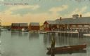
| Description: | View of a boating scene off of the shore of Marinette and Menominee. Two boys are walking on the pier on the left, and a crowd of people are gathered at th... |
| Date: | 1912 |
|---|---|
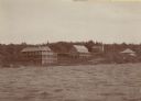
| Description: | View across water toward buildings on the right, with men standing on a platform at the shoreline in front of a large building. Three more smaller building... |
| Date: | 1910 |
|---|---|
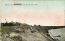
| Description: | Walkway on the bluff leading down to a pavilion on the shoreline. Houses are in the background. Caption reads: "Pavilion at Bendersville, near Green Bay, W... |
| Date: | 1955 |
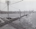
|---|---|
| Description: | Elevated view of the Milwaukee Road and Chicago & Northwestern Railway crossing on Monona Bay, the site of the old MX tower. |

| Date: | 1900 |
|---|---|
| Description: | A view of the lighthouse and dock office at Peshtigo Harbor. |
| Date: | 1905 |
|---|---|
| Description: | Elevated view looking towards the Wisconsin State Capitol from across Monona Bay. |
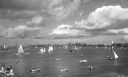
| Date: | |
|---|---|
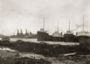
| Description: | A bay with sailboats and other small craft, and a view of the shoreline and town beyond. |
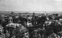
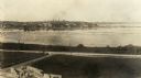
| Date: | |
|---|---|
| Description: | Elevated view looking down on the town with the bay and opposite shoreline in distance. |
| Date: | |
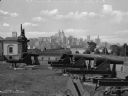
|---|---|
| Description: | A view of artillery and guns at Fort Jay, built in 1794 to defend Upper New York Bay. The New York cityscape is across the bay. |

| Date: | 1957 |
|---|---|
| Description: | Large Letter style postcard for Green Bay depicting various scenes in the letters that spell the name of the city. Caption reads: "Greetings from Green Bay... |

| Date: | 1856 |
|---|---|
| Description: | A hand-colored map of Wisconsin, showing the county boundaries, towns, cities, railroads, roads, lakes, rivers, bays, and the Lake Superior’s islands. In ... |

| Date: | 1860 |
|---|---|
| Description: | A hand-drawn, ink on cloth map of southeastern Wisconsin that show roads and railroads that connect Chicago to Milwaukee and other towns in the southeaster... |
If you didn't find the material you searched for, our Library Reference Staff can help.
Call our reference desk at 608-264-6535 or email us at: