 Filter: Categories of Wisconsin Historical Images
Filter: Subject of Bays
Filter: Subject of children
Filter: Categories of Wisconsin Historical Images
Filter: Subject of Bays
Filter: Subject of children

| Date: | 1909 |
|---|---|
| Description: | View of a boating scene off of the shore of Marinette and Menominee. Two boys are walking on the pier on the left, and a crowd of people are gathered at th... |

| Date: | 1746 |
|---|---|
| Description: | Map of North America from the southern portion of James Bay to Florida. It shows the colonies, cities, Native American land, and topological and geographic... |

| Date: | 1683 |
|---|---|
| Description: | Map of the north east coast of North America showing islands, regions, Native American land, bays, and a few European settlements. The Great Lakes appear i... |
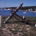
| Date: | |
|---|---|
| Description: | A wood and metal anchor is displayed on the shore of Gordon Lodge. A young girl is sitting on a floating raft in North Bay. Houses and boats are on the sho... |
If you didn't find the material you searched for, our Library Reference Staff can help.
Call our reference desk at 608-264-6535 or email us at: