 Filter: Categories of Wisconsin Historical Images
Filter: Subject of Bays
Filter: Subject of bays
Filter: Year of 1900-1999
Filter: Year of 1960-1969
Filter: Categories of Wisconsin Historical Images
Filter: Subject of Bays
Filter: Subject of bays
Filter: Year of 1900-1999
Filter: Year of 1960-1969

| Date: | 1961 |
|---|---|
| Description: | Aerial view of the Duluth-Superior bridge. |

| Date: | 1968 |
|---|---|
| Description: | A topographic map of east central Wisconsin, that covers an area stretching from Green Bay on the east to Edgar and Vesper on the west, Wausau on the north... |

| Date: | 1962 |
|---|---|
| Description: | This map shows streets, points of interest, Lake Winnebago, Millers Bay, South Asylum Bay, Lake Butte des Morts, and the Fox River. The map also includes a... |

| Date: | 1962 |
|---|---|
| Description: | This map shows streets, points of interest, Lake Winnebago, Millers Bay, South Asylum Bay, Lake Butte des Morts, and the Fox River. The map also includes a... |

| Date: | 1966 |
|---|---|
| Description: | A colored map depiction of Door County, Wisconsin, with pictorial highlights, titled: "Door County — Wisconsin's Air Conditioned Peninsula Playground." |

| Date: | 1963 |
|---|---|
| Description: | This blue line print shows as of March 1960 federal, state, county, and town roads, as well as railroads, schools, churches, town hall, parks, and Brown Co... |
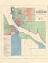
| Date: | 1961 |
|---|---|
| Description: | This map shows zoning districts, wards, and house number system and is indexed for points of interest. The upper right corner includes a color coded zoning... |
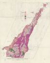
| Date: | 1961 |
|---|---|
| Description: | This map shows bays, lakes, and roads. Relief is shown by contours; depths are shown by isolines. Lake Michigan and Lake Winnebago are labeled. An explana... |

| Date: | 1960 |
|---|---|
| Description: | This map is a facsimile of a 1829 map and shows private land claims, landowners within military reserve boundaries, sawmill, Fort Howard, public barns, bri... |

| Date: | 1960 |
|---|---|
| Description: | This map shows public boat ramps, parks, highways, beaches, bluffs, Green Bay, Garrett Bay, Europe Bay and Lake, Rowley's Bay and Ellison Bay. The map incl... |
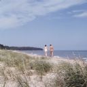
| Date: | 1967 |
|---|---|
| Description: | View across grass and sand towards a young couple, a man and woman, holding hands and walking along the shoreline of Whitefish Bay. Trees are along the cur... |

| Date: | 1969 |
|---|---|
| Description: | A woman getting ready to putt on the green at the Peninsula State Park Golf Course. A man stands on the left watching, and parked behind him is a golf cart... |

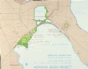
| Date: | 1960 |
|---|---|
| Description: | Air view focused on the Greenbush neighborhood of Madison prior to its demolition for the Triangle Redevelopment Project. Monona Bay and Brittingham Park a... |

| Date: | 1964 |
|---|---|
| Description: | Aerial view of the Sampson Plaza apartment complex on West Washington Avenue, with Proudfit Street running along the bottom. Neighborhood House can be seen... |
| Date: | 1967 |
|---|---|
| Description: | Schematic Master Plan for the City of Madison, Wisconsin. William Wesley Peters, Architect • The Frank Lloyd Wright Foundation. |

| Date: | 02 08 1961 |
|---|---|
| Description: | E.H. Lansdowne, 2910 Stevens Street (R), a city fireman at Station No. 4, and Tom Fawcett, 6104 Bridge Road, pilot, stand next to the Madison Police Depart... |
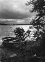
| Date: | 10 1962 |
|---|---|
| Description: | View from shoreline towards a rowboat is pulled up onto the shore of Squaw Bay on Lake Monona. Trees are in the foreground. The sky is overcast and the wat... |
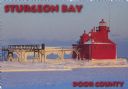
| Date: | 1963 |
|---|---|
| Description: | Text on front reads: "Sturgeon Bay, Door County." On reverse: "Sturgeon Bay, Wisconsin, Door County. North Pierhead Light. Winter shows its pretty face on ... |

| Date: | 1963 |
|---|---|
| Description: | Text on front reads: "Sherwood Point Lighthouse, Door County, Wisconsin." On reverse: "Sherwood Point Lighthouse is near Potawatomi State Park, north of St... |

| Date: | 1963 |
|---|---|
| Description: | Text on front reads: "Sherwood Point Lighthouse, Door County." On reverse: "Built in 1883, the Sherwood Point Lighthouse marks the entrance into Sturgeon B... |
If you didn't find the material you searched for, our Library Reference Staff can help.
Call our reference desk at 608-264-6535 or email us at: