 Filter: Categories of Wisconsin Historical Images
Filter: Subject of Bays
Filter: Subject of bays
Filter: Subject of bridges
Filter: Categories of Wisconsin Historical Images
Filter: Subject of Bays
Filter: Subject of bays
Filter: Subject of bridges

| Date: | 1893 |
|---|---|
| Description: | Bird's-eye map of Sturgeon Bay, looking Northeast. Area bordered by Church Street in top left corner, leather & Smith Bridge in bottom left corner, Lawrenc... |

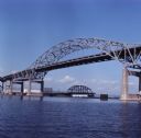
| Date: | 1961 |
|---|---|
| Description: | Aerial view of the Duluth-Superior bridge. |

| Date: | 1941 |
|---|---|
| Description: | Elevated view of Sturgeon Bay in 1900. Sturgeon Bay Bridge spans the bay and several boats are on the water. A lighthouse sits on a small island in the bay... |
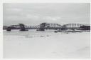
| Date: | 01 06 1958 |
|---|---|
| Description: | View from snowy shoreline of Highway Bridge, the east approach. The lake is frozen. Just beyond the shoreline a boat is moored at a landing, and an automob... |

| Date: | |
|---|---|
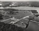
| Description: | Aerial view of harbors and bridge. Farm fields are on either side of the bridge. The city of Sturgeon Bay is in the distance. There are docks along the sho... |

| Date: | 1990 |
|---|---|
| Description: | This map shows the Minnesota Point, Wisconsin Point, Hog Island, Baker's Island, Connors Point, Blatnik Bridge, Superior Bay, Allouez Bay, the Nemadji Rive... |
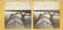
| Date: | |
|---|---|
| Description: | Stereograph of an elevated view of Howard Side of Green Bay. View looks over roofs of long, industrial buildings near railroad tracks that run over the wat... |

| Date: | 1775 |
|---|---|
| Description: | Map of Boston and surrounding regions, from Massachusetts Bay to the Connecticut River, and including part of southern New Hampshire. It shows the colonies... |

| Date: | 11 1781 |
|---|---|
| Description: | Map of New York, Staten Island, and Long Island, showing the placements of forts, and the movement of troops in 1776. The map also includes towns, cities, ... |
| Date: | |
|---|---|
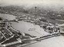
| Description: | Aerial view of Green Bay, and the Fox River headed toward the bay. Commercial and industrial buildings are on the right bank, and residential neighborhoods... |

| Date: | |
|---|---|
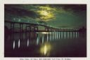
| Description: | View from shoreline of the Duluth-Superior high bridge. |
| Date: | |
|---|---|
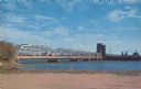
| Description: | View across water towards the Duluth-Superior bridge. |
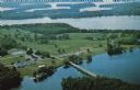
| Date: | 1950 |
|---|---|
| Description: | Aerial view of Northernaire Resort, on Deer Lake. The resort is in the foreground. Many lakes, surrounded by trees, are in the background, including Big St... |
| Date: | 1933 |
|---|---|
| Description: | Aerial view towards the southwest of International Harvester's. Burnham Harbor is in the center, with exhibit buildings on the left on Northerly Island, an... |

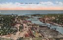
| Date: | 07 06 1931 |
|---|---|
| Description: | Text on front reads: "Where Green Bay and Sturgeon Bay Meet, Sturgeon Bay, Wis." Aerial view of Sturgeon Bay showing the only bridge in existence at the ti... |
| Date: | 1955 |
|---|---|
| Description: | Text on reverse reads: "Sturgeon Bay Drawbridge Spanning, Sturgeon Bay Canal, Sturgeon Bay, Wis." Traffic is backed up as a ship passes through the span of... |

| Date: | 1923 |
|---|---|
| Description: | Color map of the "Interborough Rapid Transit System of Greater New York". |
| Date: | 1937 |
|---|---|
| Description: | Cover title of souvenir folder reads: "Souvenir folder of Superior, Wisconsin 17 Natural Color Views. Caption for this image reads: "Nite View of New $21,0... |
| Date: | 1963 |
|---|---|
| Description: | Text on reverse reads: "Northernaire, Three Lakes, WI 54562. Phone 715 – 546-3331. The Resort Hotel that has it all." Aerial view of Northernaire Resort, o... |
If you didn't find the material you searched for, our Library Reference Staff can help.
Call our reference desk at 608-264-6535 or email us at: