 Filter: Categories of Wisconsin Historical Images
Filter: Subject of Bays
Filter: Reproduction Rights of For Sale
Filter: Year of 1700-1799
Filter: Categories of Wisconsin Historical Images
Filter: Subject of Bays
Filter: Reproduction Rights of For Sale
Filter: Year of 1700-1799

| Date: | 1791 |
|---|---|
| Description: | An English and updated version of d'Anville's 1746 map "Amérique Septentrionale Publiée sous les Auspices de Monseigneur le Duc d'Orleans Prémier Prince du... |

| Date: | 1777 |
|---|---|
| Description: | This detailed map of the American colonies shows cities, villages, roads, mountains, lakes, rivers, swamps, counties, state boundaries, and Native American... |
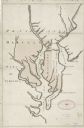
| Date: | 1732 |
|---|---|
| Description: | Map showing the the Chesapeake and Delaware Bay and surrounding land, including the rivers which drain into the bays. The border of Maryland and Delaware i... |

| Date: | 1780 |
|---|---|
| Description: | Map of Maryland and a portion of the surrounding provinces. It shows the boundary lines and borders, counties, cities, towns, roads, mountains, bays, and r... |
If you didn't find the material you searched for, our Library Reference Staff can help.
Call our reference desk at 608-264-6535 or email us at: