 Filter: Categories of Wisconsin Historical Images
Filter: Subject of Bays
Filter: Reproduction Rights of For Sale
Filter: Categories of Wisconsin Historical Images
Filter: Subject of Bays
Filter: Reproduction Rights of For Sale
| Date: | |
|---|---|
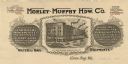
| Description: | Letterhead of the Morley-Murphy Hardware Company, with a three-quarter view of the company building and horse, streetcar, and rail traffic around it. |

| Date: | 1935 |
|---|---|
| Description: | This map shows streets, railroads, and city wards. Streets, the Oconto River, and the Green Bay are labeled. The bottom of the map reads: "Compliments of O... |

| Date: | 09 1950 |
|---|---|
| Description: | This map show streets, points of interest, Lake Winnebago and bays, Lake Butte Des Morts, and the Fox River. The back of the map includes a directory of t... |

| Date: | 1962 |
|---|---|
| Description: | This map shows streets, points of interest, Lake Winnebago, Millers Bay, South Asylum Bay, Lake Butte des Morts, and the Fox River. The map also includes a... |

| Date: | 1962 |
|---|---|
| Description: | This map shows streets, points of interest, Lake Winnebago, Millers Bay, South Asylum Bay, Lake Butte des Morts, and the Fox River. The map also includes a... |

| Date: | 1874 |
|---|---|
| Description: | This map shows streets, buildings, railroads, the Fox River, the East River, and part of Green Bay. |

| Date: | 1898 |
|---|---|
| Description: | This map shows blocks, industrial buildings, and railroads in portions of Duluth and Superior, as well as harbor lines, areas improved, and proposed improv... |

| Date: | 1901 |
|---|---|
| Description: | This map shows streets, industrial buildings, a portion of Lake Superior and other lakes, bays, and rivers in portions of Duluth and Superior. Relief is sh... |

| Date: | 1914 |
|---|---|
| Description: | This map shows streets, industrial buildings, a portion of Lake Superior and other lakes, bays, and rivers in portions of Duluth and Superior. Relief is sh... |

| Date: | 1919 |
|---|---|
| Description: | This map shows details of the harbor, proposed route and bridge changes, railroads, streets, selected buildings, a portion of Lake Superior and other lakes... |

| Date: | 1886 |
|---|---|
| Description: | This map shows lot and block numbers, sold lots, established dock lines, docks, slips, railroads, industrial buildings, streets, and the St. Louis Bay. |

| Date: | 1966 |
|---|---|
| Description: | A colored map depiction of Door County, Wisconsin, with pictorial highlights, titled: "Door County — Wisconsin's Air Conditioned Peninsula Playground." |
| Date: | 1940 |
|---|---|
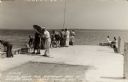
| Description: | Photographic postcard view looking out at people standing, and some fishing, on the Northport pier at Death's Door, with the bay in the background. |

| Date: | 1908 |
|---|---|
| Description: | This map shows streets, industrial buildings, a portion of Lake Superior and other lakes, bays, and rivers in portions of Duluth and Superior. Relief is sh... |

| Date: | 06 1923 |
|---|---|
| Description: | Sanborn map of Ashland, which includes Chequamegon Bay. |

| Date: | 06 30 1893 |
|---|---|
| Description: | This map shows selected industrial buildings, streets, railroads, docks, and beacons in West Duluth, Duluth, West Superior, and Superior, as well as the St... |

| Date: | 1892 |
|---|---|
| Description: | This map shows the St. Louis Bay, Lake Superior, railroads, railroad yards, main roads, additions, and selected buildings in Superior and parts of the Town... |

| Date: | 01 06 1958 |
|---|---|
| Description: | Ahnapee & Western Railway Bridge construction. View is from Highway Bridge. There are ships on the right side beyond the bridge. The forested shoreline cur... |

| Date: | 01 06 1958 |
|---|---|
| Description: | Ahnapee & Western Railway Bridge from north side of frozen Sturgeon Bay. The bridge is made of wood (and steel supports???). There is a dock in the foregro... |
If you didn't find the material you searched for, our Library Reference Staff can help.
Call our reference desk at 608-264-6535 or email us at:
