 Filter: Categories of Wisconsin Historical Images
Filter: Subject of Bays
Filter: County of Door
Filter: Categories of Wisconsin Historical Images
Filter: Subject of Bays
Filter: County of Door

| Date: | 01 06 1958 |
|---|---|
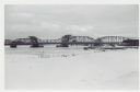
| Description: | Ahnapee & Western Railway Bridge from north side of frozen Sturgeon Bay. The bridge is made of wood (and steel supports???). There is a dock in the foregro... |

| Date: | 01 06 1958 |
|---|---|
| Description: | View of the Ship Canal from the Coast Guard station. There are pieces of machinery on the right, and a line of trees on the left. There is snow on the grou... |
| Date: | 01 06 1958 |
|---|---|
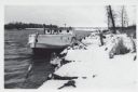
| Description: | View from snowy shoreline of Mooring Basin at bay end of Ship Canal. The boat moored in the foreground is named "Allie." It is tethered to a post on the sh... |
| Date: | 01 06 1958 |
|---|---|
| Description: | View from snowy shoreline of Highway Bridge, the east approach. The lake is frozen. Just beyond the shoreline a boat is moored at a landing, and an automob... |
| Date: | |
|---|---|
| Description: | View across water towards a group of people, men, woman, and young girls and boys, posing on a pier in front of a building on the shoreline of Sister Bay. ... |

| Date: | |
|---|---|
| Description: | Aerial view of harbors and bridge. Farm fields are on either side of the bridge. The city of Sturgeon Bay is in the distance. There are docks along the sho... |
| Date: | 1961 |
|---|---|
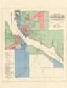
| Description: | This map shows zoning districts, wards, and house number system and is indexed for points of interest. The upper right corner includes a color coded zoning... |

| Date: | 04 1926 |
|---|---|
| Description: | This blueprint mostly shows various numbers within the canal and bay. Lake Michigan and Harobor of Refuge are shown along the far right side. Near the harb... |

| Date: | 1960 |
|---|---|
| Description: | This map shows public boat ramps, parks, highways, beaches, bluffs, Green Bay, Garrett Bay, Europe Bay and Lake, Rowley's Bay and Ellison Bay. The map incl... |
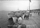
| Date: | 1940 |
|---|---|
| Description: | View of a crowd gathered along a pier for Regatta Day. Boats are docked alongside the pier on the left. |

| Date: | 1936 |
|---|---|
| Description: | This map shows campsites, trails, auto roads, surrounding townships, and points of interest, by including pictorial illustrations. Includes an inserted map... |
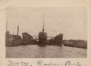
| Date: | 1902 |
|---|---|
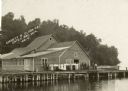
| Description: | View across water towards a ship docked in a floating harbor at Sturgeon Bay. There is a shoreline in the background. |
| Date: | 1910 |
|---|---|
| Description: | View along shoreline of Weborg Point before the area became Peninsula State Park. Green Bay is on the left. Two wood buildings are along the shoreline in t... |
| Date: | |
|---|---|
| Description: | Colored postcard view near the extreme northern point of Door County. There is a man standing on the left in a field of flowers looking at the bay. Fishing... |
| Date: | |
|---|---|
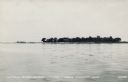
| Description: | View across water towards Little Strawberry Island in Green Bay. The beach on the left side of the island is sandy, and a house can be seen among the trees... |
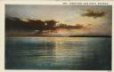
| Date: | 1932 |
|---|---|
| Description: | Color postcard view of a brilliant sunset over Green Bay. There is a forested shoreline in the distance. Caption reads: "Sunset View, Door County, Wisconsi... |
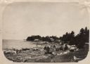
| Date: | |
|---|---|
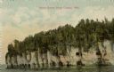
| Description: | View across water towards the bluffs at the northern end of Door County. |
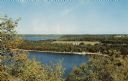
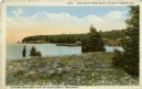
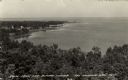
| Date: | 1957 |
|---|---|
| Description: | Elevated view of Little Sister Bay and the surrounding landscape. |
| Date: | |
|---|---|
| Description: | Elevated view of Green Bay from the Alpine Tower at Egg Harbor. A few dwellings are along the shoreline on the left. Caption reads: "View from the Alpine T... |
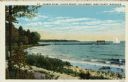
| Date: | 1932 |
|---|---|
| Description: | Colorized postcard of Green Bay from Egg Harbor. A long pier with a rowboat at the side and a sailboat at the end. Caption reads: "Harbor Scene - Alpine Re... |
If you didn't find the material you searched for, our Library Reference Staff can help.
Call our reference desk at 608-264-6535 or email us at: