 Filter: Categories of Wisconsin Historical Images
Filter: Subject of Bays
Filter: County of Bayfield
Filter: Community of Washburn
Filter: Categories of Wisconsin Historical Images
Filter: Subject of Bays
Filter: County of Bayfield
Filter: Community of Washburn

| Date: | |
|---|---|
| Description: | Exterior of the menu for Paul's Cafe, with a bird's-eye view map of "Washburn's Natural Deep Water Land Locked Harbor," Chequamegon Bay, and the Apostle Is... |

| Date: | 1918 |
|---|---|
| Description: | Manuscript map of the Chequamegon Bay area on Lake Superior drawn by Warren W. Witmer and illustrated with sketches by Mary L. Wright Witmer in ink and wat... |
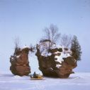
| Date: | |
|---|---|
| Description: | View across frozen bay towards a person riding a snowmobile in front of a split rock formation on Chequamegon Bay. |

| Date: | 09 1918 |
|---|---|
| Description: | An insurance map of Washburn, with an index and a key. Includes a small inset map of the State of Wisconsin that shows "Location of this town as above unde... |
If you didn't find the material you searched for, our Library Reference Staff can help.
Call our reference desk at 608-264-6535 or email us at: