 Filter: Categories of Wisconsin Historical Images
Filter: Subject of Battles
Filter: Subject of military art and science
Filter: Categories of Wisconsin Historical Images
Filter: Subject of Battles
Filter: Subject of military art and science
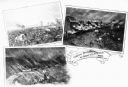
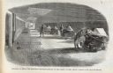
| Date: | 1862 |
|---|---|
| Description: | A composite of three views showing the siege of New Ulm on August 19 during the Indian Massacre of 1862. The lower left view depicts wagons and horses on a... |
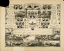
| Date: | |
|---|---|
| Description: | Commemorative poster honoring duties of the States and those that fought and lead the war. |
| Date: | 1860 |
|---|---|
| Description: | Four Union soldiers chasing four Confederate soldiers. The Union soldiers have a Union flag, a cannon and rifles with bayonets. The four Confederate soldie... |

| Date: | 1860 |
|---|---|
| Description: | A Union sailor and King Neptune stand inside a sea shell that is floating on the ocean. Between them appears a decorative circle with the Union Armada in i... |
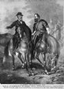
| Date: | |
|---|---|
| Description: | Copy of a painting entitled, "Last Meeting of General Robert E. Lee and Stonewall Jackson." The scene depicts the meeting at the Battle of Chancellorsvill... |

| Date: | 1860 |
|---|---|
| Description: | A youthful looking Zouave soldier has a knife in his right hand and the Union flag in his left. A battlefield with explosions is behind him. The verse bel... |

| Date: | 1860 |
|---|---|
| Description: | An old woman, stooped over and holding a cane, has Union soldiers ("NORTH" on the left) and Confederate soldiers ("SOUTH" on the right) climbing ladders to... |
| Date: | 02 22 1862 |
|---|---|
| Description: | Engraved illustration for the story titled: "The Capture of Fort Henry". The drawing is of a gun-deck of a Mississippi gun boat. |
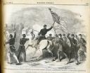
| Date: | 07 27 1861 |
|---|---|
| Description: | The caption with the image states, "Battle of Hoke's Run-Col. Starkweather with his Wisconsin Regiment deploying as skirmishers." The Battle of Hoke's Run ... |
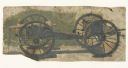
| Date: | 1886 |
|---|---|
| Description: | Oil on linen study of a Civil War cannon with ammunition wagon attached. The painting was created by one of a group of German panorama painters active in ... |

| Date: | 1864 |
|---|---|
| Description: | This map of the Battle of Gettysburg indicates Union positions in red and Confederate positions in blue. Also shown are artillery positions, roads, railroa... |

| Date: | 1850 |
|---|---|
| Description: | A hand-colored map showing portions of present-day Iron and Vilas counties north of the Manitowish River as part of the Upper Peninsula of Michigan. The Wi... |

| Date: | 1862 |
|---|---|
| Description: | This map illustrates the official plan for the siege of Yorktown, Virginia, and indicates the headquarters of Generals McClellan, Porter, Woodbury, and Hei... |
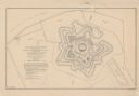
| Date: | 1862 |
|---|---|
| Description: | This detailed plan of Fort Jackson, in Plaquemines Parish, Louisiana, indicates the damage inflicted by the April, 1862, bombardment of the fort by Union f... |

| Date: | 1862 |
|---|---|
| Description: | This map shows the region of southeastern Virginia which served as the setting for the Peninsular Campaign of 1862. A few battle sites are marked by crosse... |

| Date: | 1862 |
|---|---|
| Description: | This map of the Mississippi River between Island No. 8, northeast of New Madrid, Missouri, and Tiptonville, Tennessee, depicts the Confederate defenses at ... |

| Date: | 1862 |
|---|---|
| Description: | This pen and ink drawing of the First Battle of Bull Run, JuIy 21st, 1861, was made by Charles K. Dean, adjutant with the 2nd Wisconsin Infantry. The 2nd W... |

| Date: | 1863 |
|---|---|
| Description: | This map is a hand-colored, pen and ink, drawing by Ole R. Dahl of Co. B, 15 Wisconsin Infantry shows the battlefield at Stones River, depicting roads, str... |

| Date: | 1863 |
|---|---|
| Description: | These detailed topographical maps of the Battle of Gettysburg show drainage, vegetation, roads, railroads, fences, houses with names of residents, and a de... |

| Date: | 1863 |
|---|---|
| Description: | These detailed topographical maps of the Battle of Gettysburg show drainage, vegetation, roads, railroads, fences, houses with names of residents, and a de... |
If you didn't find the material you searched for, our Library Reference Staff can help.
Call our reference desk at 608-264-6535 or email us at: