Filter: Categories of Wisconsin Historical Images
Filter: Subject of Battlefields
Filter: Year of 1800-1899
Filter: Year of 1890-1899
Filter: Categories of Wisconsin Historical Images
Filter: Subject of Battlefields
Filter: Year of 1800-1899
Filter: Year of 1890-1899
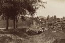
| Date: | 1890 |
|---|---|
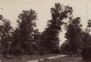
| Description: | Site of the Battle to Antietam, The Dunker Church. A group of men stand among trees on the left. Horse-drawn carriages are under trees on the right. |
| Date: | 1890 |
|---|---|
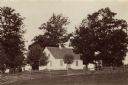
| Description: | Hagerstown Pike. A brick wall and trees are along the road on the right. |
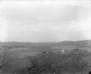
| Date: | 1896 |
|---|---|
| Description: | Elevated view. Caption on negative sleeve reads: "Black Hawk Battlefield. Wis. Heights. 'Looking it of west across river' [sic] c. 1896. Mrs. Charle... |
| Date: | 1896 |
|---|---|
| Description: | Elevated view. Caption on negative sleeve reads: "Black Hawk Battlefield. Wis. Heights. Looking N. of E. up valley towards Catholic Church. Mrs. Charles N.... |
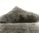
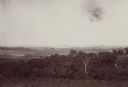
| Date: | 1896 |
|---|---|
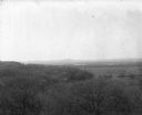
| Description: | View of Black Hawk Bluff, site of the Battle of Wisconsin Heights in the Black Hawk War. |
| Date: | 1890 |
|---|---|
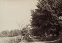
| Description: | Site of the Battle of Antietam. The bloody lane. |
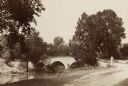
| Date: | 1890 |
|---|---|
| Description: | Site of the Battle of Antietam, the Burnside Bridge. |
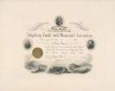
| Date: | 1895 |
|---|---|
| Description: | Certificate appointing Lucius Fairchild as the director of the Gettysburg Battle Field Memorial Association. The certificate is decorated with oval portrai... |
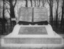
| Date: | 1890 |
|---|---|
| Description: | "Commands Honored" monument in the form of a large bronze book opened to pages reading "High Water Mark on the Rebellion" and "Repulse of Longstreet's Assa... |
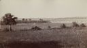
| Date: | 1890 |
|---|---|
| Description: | View of the field where Pickett's charge took place during the Battle of Gettysburg. |

| Date: | 05 01 1899 |
|---|---|
| Description: | Map showing the Schuylkill River with roads, ferries, and points of interest from Valley Forge to Philadelphia, Pennsylvania as it appeared during the Revo... |
| Date: | 08 1898 |
|---|---|
| Description: | Caption reads: "View from N.E. 1/4 of S.E. 1/4 Sec. 36 L. 12 R 7 W. looking toward Victory, Vernon Co. Wis., showing last 4 miles of trail of Atkinson's Ar... |
If you didn't find the material you searched for, our Library Reference Staff can help.
Call our reference desk at 608-264-6535 or email us at: