 Filter: Categories of Wisconsin Historical Images
Filter: Subject of Battlefields
Filter: Subject of transportation
Filter: Subject of fences
Filter: Categories of Wisconsin Historical Images
Filter: Subject of Battlefields
Filter: Subject of transportation
Filter: Subject of fences
| Date: | 1890 |
|---|---|
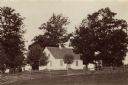
| Description: | Site of the Battle to Antietam, The Dunker Church. A group of men stand among trees on the left. Horse-drawn carriages are under trees on the right. |
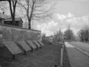
| Date: | 1890 |
|---|---|
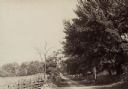
| Description: | Hagerstown Pike. A brick wall and trees are along the road on the right. |
| Date: | 1889 |
|---|---|
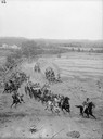
| Description: | Stereograph from the Chicago Panorama of the Battle of Gettysburg Representing Pickett's Charge at 4 P.M., July 3rd, 1863: Wheelers Battery Coming into Act... |
| Date: | 1890 |
|---|---|
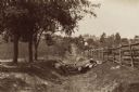
| Description: | Site of the Battle of Antietam. The bloody lane. |

| Date: | 1900 |
|---|---|
| Description: | Railroad redoubt seen from the north showing the slope where General Grant's column charged on May 22, 1863, during the siege of Vicksburg. |
| Date: | |
|---|---|
| Description: | A view of eight commemorative tablets at the North Cemetery of Antietam Battlefield, the site of the bloodiest one-day battle in United States history in 1... |
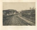
| Date: | 1866 |
|---|---|
| Description: | View from railroad tracks through the Allatoona Pass. One of the buildings on the left says "Grocery," and piles of lumber are stacked along the sides of t... |

| Date: | 1863 |
|---|---|
| Description: | These detailed topographical maps of the Battle of Gettysburg show drainage, vegetation, roads, railroads, fences, houses with names of residents, and a de... |

| Date: | 1863 |
|---|---|
| Description: | These detailed topographical maps of the Battle of Gettysburg show drainage, vegetation, roads, railroads, fences, houses with names of residents, and a de... |

| Date: | 1863 |
|---|---|
| Description: | This colored map of the Battle of Chattanooga depicts the positions of the Union and Confederate troops before the battle and on each day of the battle. Al... |

| Date: | |
|---|---|
| Description: | Pen and ink tracing showing the positions of Union and Confederate soldiers, troop camps, location of graves, roads, drainage, vegetation, houses, and fenc... |
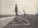
| Date: | 1903 |
|---|---|
| Description: | Statue of John L. Burns, the elderly citizen-hero of the Battle of Gettysburg, who fought with the 7th Wisconsin on July 1, 1863 and was wounded. A veteran... |
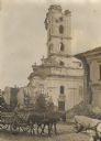
| Date: | 1914 |
|---|---|
| Description: | A man is driving a team of two horses pulling a wagon on a street in front of a ruined church. Rubble is piled in front of another building on the right. |
If you didn't find the material you searched for, our Library Reference Staff can help.
Call our reference desk at 608-264-6535 or email us at: