Filter: Categories of Wisconsin Historical Images
Filter: Subject of Battlefields
Filter: Subject of roads
Filter: Creator Name of Unknown
Filter: Categories of Wisconsin Historical Images
Filter: Subject of Battlefields
Filter: Subject of roads
Filter: Creator Name of Unknown
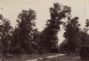
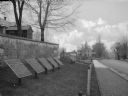
| Date: | 1890 |
|---|---|
| Description: | Hagerstown Pike. A brick wall and trees are along the road on the right. |
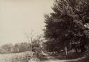
| Date: | 1890 |
|---|---|
| Description: | Site of the Battle of Antietam. The bloody lane. |
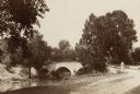
| Date: | 1890 |
|---|---|
| Description: | Site of the Battle of Antietam, the Burnside Bridge. |
| Date: | |
|---|---|
| Description: | A view of eight commemorative tablets at the North Cemetery of Antietam Battlefield, the site of the bloodiest one-day battle in United States history in 1... |

| Date: | |
|---|---|
| Description: | Pen and ink tracing showing the positions of Union and Confederate soldiers, troop camps, location of graves, roads, drainage, vegetation, houses, and fenc... |

| Date: | 1915 |
|---|---|
| Description: | This 1915 map covers portions of Barron, Chippewa, and Rusk counties in Wisconsin. Shown are the township and range grid, sections, cities and villages, ra... |
If you didn't find the material you searched for, our Library Reference Staff can help.
Call our reference desk at 608-264-6535 or email us at: