 Filter: Categories of Wisconsin Historical Images
Filter: Subject of Battlefields
Filter: Subject of ocean
Filter: Categories of Wisconsin Historical Images
Filter: Subject of Battlefields
Filter: Subject of ocean
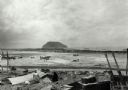
| Date: | 02 1945 |
|---|---|
| Description: | Airfield #1, Iwo Jima, with Mt Surabachi in the distance. This image is one of many taken by Milwaukee photographer Dickey Chapelle during the assault on ... |
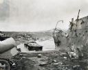
| Date: | 1945 |
|---|---|
| Description: | Parts of destroyed boats and military equipment on the shoreline of Iwo Jima on D-Day. |
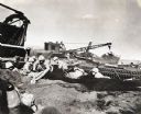
| Date: | 1945 |
|---|---|
| Description: | Marines dig foxholes into the sand on the beaches of Iwo Jima. The men are surrounded by military equipment, including a crane. An International Diesel cra... |

| Date: | 1862 |
|---|---|
| Description: | This map of the southeastern United States shows forts and battlefields, railroads, rivers, and cities and towns. Dates of admission and secession of the s... |

| Date: | 1863 |
|---|---|
| Description: | A general map of the southeastern United States showing Missouri, Kentucky, West Virginia, Virginia, North Carolina, South Carolina, Georgia, Florida, Alab... |

| Date: | 1864 |
|---|---|
| Description: | A map of Sherman's March from Atlanta, Georgia to Goldsboro, North Carolina. |
If you didn't find the material you searched for, our Library Reference Staff can help.
Call our reference desk at 608-264-6535 or email us at: