 Filter: Categories of Wisconsin Historical Images
Filter: Subject of Battlefields
Filter: Subject of lakes
Filter: Categories of Wisconsin Historical Images
Filter: Subject of Battlefields
Filter: Subject of lakes

| Date: | 1864 |
|---|---|
| Description: | This colored map of the southern and eastern states shows locations of battles and skirmishes from 1861 through May 1864 with red dots or red underlining o... |

| Date: | 1915 |
|---|---|
| Description: | This 1915 map covers portions of Barron, Chippewa, and Rusk counties in Wisconsin. Shown are the township and range grid, sections, cities and villages, ra... |

| Date: | 1887 |
|---|---|
| Description: | Map of the Fox and Wisconsin Rivers to accompany Reuben Gold Thwaites' Historic Waterways. |
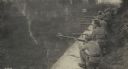
| Date: | |
|---|---|
| Description: | Guarding the embankment of Caldonazzo on the Tirolian battlefront. |

| Date: | |
|---|---|
| Description: | Even the calm surface of the Duerersee (Lake Duerer) must be watched steadily to ensure that there are no enemy surprises from this area. |

| Date: | |
|---|---|
| Description: | Concrete machinegun nest on the Molvenosee (Lake Molveno). |
If you didn't find the material you searched for, our Library Reference Staff can help.
Call our reference desk at 608-264-6535 or email us at: